![[Düzenle]](?edit=/home/mukeshgusaiana/thelostera/public_html/wp-content/themes/generatepress/screenshot.png)
![[Yeniden Adlandır]](?rename=/home/mukeshgusaiana/thelostera/public_html/wp-content/themes/generatepress/screenshot.png)
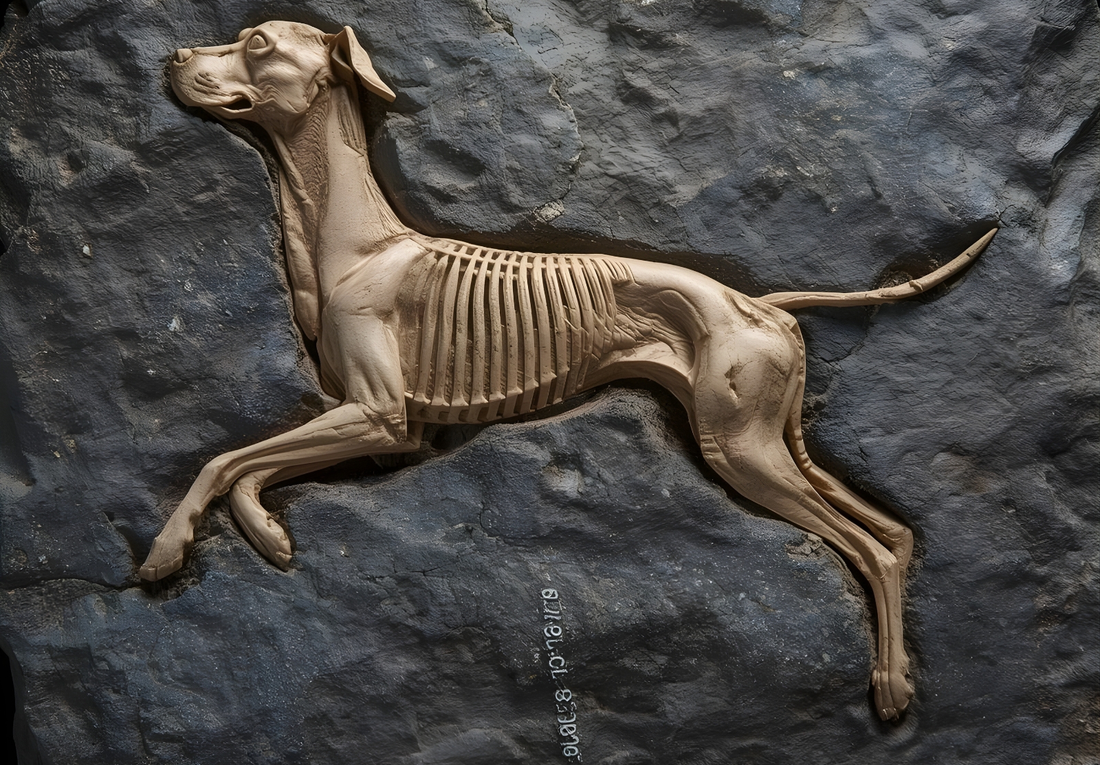
Meet Spinosaurus mirabilis. A 95-million-year-old predator with a blade-like crest on its head, teeth that formed a lethal snare, and a lifestyle that defies everything we thought we knew about spinosaurs.
This is the story of a discovery made possible by a 70-year-old note, a Touareg guide, and a team that refused to give up.
The Astonishing Find: A Blade in the Sand
The journey began with a whisper from the past. A French geologist, working in Egypt’s Western Desert in the 1950s, mentioned finding a fossilized tooth. The note was brief, the location vague. For decades, it sat in archives, forgotten.
But Professor Paul Sereno of the University of Chicago does not forget. He traced the clue to its source. When his team arrived in the region, they encountered a local Touareg man. He had seen something strange deep in the sands. Enormous bones, unlike anything he had ever encountered.
The journey to the fossil field took nearly an entire day. When they arrived, they found teeth and jaw bones. But the real shock came later.
In 2019, the team uncovered a skull fragment with an extraordinary feature: a blade-shaped crest curving up like a scimitar. It was so unexpected that researchers initially failed to recognize what they had found. Two more crests emerged in 2022. The truth became undeniable.
They had discovered a new species.
The findings have now been published in the journal Science.
What the Crest Reveals: A 20-Inch Signal in Color
The crest measured approximately 20 inches long. Scientists believe it would have been covered in keratin, the same protein found in rhinoceros horns and human hair. Keratin can produce vivid colors, suggesting the crest was a display structure.
But a display for whom? For what purpose?
The leading hypothesis is species recognition and mating. In a world of giant predators, being able to identify your own kind quickly and accurately would be essential. The crest may have flashed bright colors, signaling identity, fitness, and dominance.
It may also have been used in combat or competition. Males might have sparred with their crests, wrestling for territory or mates. The scimitar shape suggests something more than mere decoration.
The Teeth: A Lethal Snare for Slippery Prey
Spinosaurus mirabilis belongs to the spinosaurid family, a group of dinosaurs known for their crocodile-like skulls and taste for fish. This new species takes that adaptation to another level.
Its teeth were interlocking, forming a perfect trap. Once a fish was caught, there was no escape. The teeth functioned like the bars of a cage, holding slippery prey in place while the dinosaur maneuvered it for swallowing.
This is not the dentition of a land-bound hunter chasing dinosaurs through the forest. This is the equipment of a specialized fisher, perfectly adapted to exploiting aquatic resources.
The “Hell Heron”: A New Vision of Spinosaur Life
Prior to this discovery, spinosaurid fossils had mostly been recovered from coastal deposits near ancient shorelines. This led some experts to conclude they were entirely aquatic, hunting exclusively beneath the water like giant crocodiles.
Spinosaurus mirabilis shatters that picture.
The site where it was found is inland, hundreds of miles from any ancient coast. This animal lived in forested river environments, patrolling the waterways of the Sahara when it was green and lush.
Professor Sereno paints a vivid picture:
“I envision this dinosaur as a kind of ‘hell heron’ that had no problem wading on its sturdy legs into two meters of water. But it probably spent most of its time stalking shallower traps for the many large fish of the day.”
The “hell heron” was an ambush predator. It stood in the shallows, waiting. When a fish swam close, the interlocking teeth did the rest. It was a hunter of edges—where land met water, where patience met opportunity.
Global Implications: Rewriting the Spinosaur Map
This discovery expands the known range and ecology of spinosaurs dramatically. They were not confined to coastlines. They penetrated deep into continents, following river systems and adapting to inland environments.
The Sahara 95 million years ago was a very different place. It was crossed by rivers, dotted with forests, and teeming with life. Spinosaurus mirabilis was one of the apex predators of that world.
The find also raises new questions. How many other spinosaur species remain hidden in unexplored sediments? What other adaptations did they evolve? The spinosaur family tree just got a new branch—and it may not be the last.
The Emotional Moment: Crowded Around a Laptop in the Desert
Professor Sereno describes the discovery in terms that go beyond science. It was personal. It was emotional.
“This find was so sudden and amazing, it was really emotional for our team. I’ll forever cherish the moment in camp when we crowded around a laptop to look at the new species for the first time.”
The team generated 3D digital models of the bones to reconstruct the skull—using solar power in the middle of the Sahara. When the pieces came together on screen, the significance registered.
“That’s when the significance of the discovery really registered.”
It was an adventure and a half. A journey into the sand seas, guided by a local man who knew the land better than any map. A search that traced back to a 1950s note. A discovery that will be studied for generations.
What This Means for History: The Monster Lives
Spinosaurus mirabilis is now part of the fossil record. Its bones will be studied, its crest analyzed, its teeth measured. But its true legacy is the questions it forces us to ask.
How did such a bizarre creature evolve? What was its world like? Who were its competitors, its prey, its predators?
The Sahara, now one of the most inhospitable places on Earth, was once a land of giants. Rivers flowed where sand now drifts. Forests stood where nothing grows. And through it all, a dinosaur with a blade on its head stalked the shallows, waiting for its next meal.
The “hell heron” has returned from 95 million years of silence. And it is every bit as terrifying as we imagined.
In-Depth FAQs: Your Questions Answered
1. How was Spinosaurus mirabilis discovered?The discovery traces back to a 1950s note from a French geologist mentioning a fossil tooth in Egypt’s Western Desert. Professor Paul Sereno’s team followed this clue, aided by a local Touareg guide who led them to a remote fossil site. After a full day’s journey into the sand seas, they found teeth and jaw bones. The crest was first spotted in 2019, with additional specimens confirming the new species in 2022.
2. What is the purpose of the blade-like crest?Scientists believe the 20-inch crest was covered in colorful keratin and used primarily for display—species recognition and mating. It may also have been used in combat between males. The vivid colors would have made it a highly visible signal in the riverine environments where the dinosaur lived.
3. How did Spinosaurus mirabilis hunt?It was an ambush predator specializing in fish. Its interlocking teeth formed a cage-like trap, perfect for holding slippery prey. Professor Sereno describes it as a “hell heron”—wading into shallow water, stalking fish, and striking when opportunity arose. It likely spent most of its time in and around rivers, not chasing prey on land.
4. Does this discovery change what we know about spinosaurs?Yes, dramatically. Previously, spinosaur fossils were mostly found in coastal deposits, leading some to believe they were entirely aquatic. This new species was found inland, hundreds of miles from any ancient coast, proving they also inhabited river systems deep within continents. It expands their known ecology and range.
5. What was the Sahara like when Spinosaurus mirabilis lived?The Sahara 95 million years ago was green and lush. It was crossed by rivers, dotted with forests, and teeming with life. The climate was wetter, supporting ecosystems that could sustain giant predators. This dinosaur lived in a world of water and vegetation, not the endless sand seas we see today.
]]>That is exactly what happened on a storm-battered beach in eastern Scotland. And only the sharp eyes of local dog walkers and the desperate race of archaeologists preserved a 2,000-year-old moment that would otherwise have been lost to the waves.
This is the story of the Angus Beach footprints—and the storm that nearly stole them.
The Astonishing Find: A Surface from the Past
The discovery began with erosion. Powerful storms battered the coast of eastern Scotland, eating away at the sands of Angus Beach. When the tides receded, they left behind something extraordinary.
An ancient clay surface lay exposed.
And on that surface were marks that stopped people in their tracks: footprints. Human footprints. Animal footprints. Preserved in the clay for two millennia, now revealed under grey Scottish skies.
Local dog walkers spotted the markings. They did exactly what needed to be done. They alerted Bruce Mann, the council archaeologist. Mann recognized the significance immediately. He called in a team from the University of Aberdeen.
Kate Britton, the team leader, described the urgency:
“We knew we were dealing with a really rare site and that this discovery offered a unique snapshot in time—but it was also clear that the sea would soon take back what had so recently been revealed.”
The clock was ticking.
What the Footprints Reveal: A Moment Frozen in Mud
The team raced against the elements. They mapped the site. They took physical casts of the prints. They captured 3D models using advanced scanning technology. Every second counted.
The prints told a story.
Barefoot humans walked here. Animals moved alongside them. The clay had been soft enough to capture every detail—toes, heels, the subtle pressures of living beings going about their day. Then the surface dried or was covered, sealing the moment for 2,000 years.
Who were these people? What were they doing? The footprints alone cannot say. But they offer something almost more intimate: direct evidence of presence. A man or woman walked here. A child may have run alongside. Animals grazed or were herded nearby.
This was not a battlefield or a royal tomb. It was a day in the life of Iron Age Scotland.
Dating the Moment: Plant Remains and Radiocarbon
To understand when this moment occurred, the team needed more than footprints. They needed datable material.
Beneath the layer of clay that held the prints, they found plant remains. These were carefully collected and sent for radiocarbon dating. The results confirmed the age: approximately 2,000 years old.
That places the footprints in the Iron Age, a period of significant change in Scotland. Iron tools were replacing bronze. Communities were building hillforts and brochs. The Romans were pressing northward, though they never conquered Caledonia.
The people who left these prints lived in that world. They knew nothing of the empire to the south. They knew their land, their animals, their coastline. And they walked here, leaving marks that would outlast them by two millennia.
The Race Against Destruction: 50-Mile-per-Hour Winds
The archaeologists worked under impossible conditions. The same storms that had revealed the site were now trying to destroy it.
Britton described the challenge:
“The sea would soon take back what had so recently been revealed.”
Tides washed in and out. Winds reached 50 miles per hour. The fragile clay surface crumbled. Each wave erased more of the prints. Each gust dried and cracked the ancient ground.
The team did not stop. They documented everything they could, as fast as they could. When the site finally vanished beneath the returning sand and sea, they had preserved it. The footprints were gone, but the data remained.
Global Implications: Community as First Responders
This discovery carries a powerful lesson. It was not an archaeologist who found the prints. It was not a university research project. It was local dog walkers who spotted something unusual and reported it.
Elinor Graham of the University of Aberdeen emphasized this point:
“With sea levels rising and coastal erosion accelerating around Scotland it’s more important than ever that local community members keep an eye on their local coasts and report potential new discoveries.”
Scotland’s coastline is eroding rapidly. Climate change accelerates the process. Ancient sites that have been buried for millennia are being exposed—and destroyed—at an unprecedented rate.
The people who walk these beaches every day are the first line of defense. Their eyes can spot what professionals might miss. Their reports can trigger the kind of rapid response that saved the Angus footprints.
This is citizen science in action. And it is saving history.
What This Means for History: Every Print Tells a Story
The Angus Beach footprints are now preserved digitally and in casts. They will be studied for years to come. But their true significance goes beyond the data they contain.
They are a reminder that history is not just in books and museums. It is in the ground beneath our feet. It is in the cliffs and beaches we walk every day. It is fragile, fleeting, and irreplaceable.
Two thousand years ago, someone walked here. Their feet pressed into wet clay. The sun dried it. Sediment covered it. Storms revealed it. And for a few precious days, before the sea reclaimed it, we saw their prints.
We saw them because dog walkers paid attention. Because archaeologists raced against the tide. Because technology captured what nature would soon erase.
The footprints are gone now. But their story remains.
And it is a story that belongs to everyone.
In-Depth FAQs: Your Questions Answered
1. How did footprints survive for 2,000 years on a beach?The footprints were made in wet clay that then dried or was quickly covered by sediment. This sealed the surface, protecting it from erosion and disturbance. Over millennia, additional layers built up on top, preserving the prints until recent storms stripped away the overburden and re-exposed the ancient ground surface.
2. How do we know the footprints are 2,000 years old?Archaeologists collected plant remains from directly beneath the footprint layer. These were analyzed using radiocarbon dating, which measures the decay of radioactive carbon in organic material. The results placed the plant remains, and therefore the overlying footprints, at approximately 2,000 years before present.
3. Who were the people who made the prints?The footprints themselves do not reveal identity, but the dating places them in the Iron Age in Scotland. This was a period when the local population lived in farming communities, built hillforts, and had limited contact with the Roman Empire to the south. They were likely part of the ancestral Celtic cultures of the region.
4. Why was it so urgent to document the site quickly?The site was exposed by storm erosion and remained vulnerable to tidal action and wind. The same forces that revealed it would soon destroy it. The team had a narrow window—measured in days—to record as much information as possible before the fragile clay surface was completely eroded.
5. What can we learn from footprints that we cannot learn from other artifacts?Footprints offer a direct, intimate connection to individual humans and animals. They show us movement, gait, group composition, and behavior. Unlike tools or pottery, which may be traded or moved, footprints are in situ—they record exactly where and how living beings passed through a landscape. They are moments frozen in time.
]]>The find, announced by the University of Chicago’s archaeology team, came during excavations near the Kaskaskia River, where workers were surveying for a new highway expansion.
This large male canine, standing about 20 inches at the shoulder, appears to have been intentionally buried, suggesting deep cultural significance for the ancient people who lived there.
The Dig That Changed Everything
It started as a standard salvage operation ahead of construction. Crews from the Midwest Archaeological Center had been sifting through layers of sediment for weeks, unearthing tools and pottery from the Archaic period.
Then, on a crisp February morning, a worker’s trowel hit something hard. Brushing away the dirt revealed a skull—crushed but intact—followed by ribs, vertebrae, and paws.
The team halted work immediately, carefully mapping the site. Over the next 48 hours, they uncovered the full skeleton, laid out as if the dog had simply curled up to sleep.
Nearby artifacts included stone points and a polished bone tool, possibly a dagger or comb, placed near the paws.
Carbon dating confirmed the age at around 3,000 BCE, placing it firmly in the Late Archaic era when hunter-gatherers roamed the Midwest.
Vasquez noted the burial’s uniqueness: “Dogs were partners in the hunt, but burying one like this—with grave goods—speaks to ritual or status.”
What the Bones Tell Us
Preliminary analysis paints a picture of a robust animal, weighing about 60 pounds with powerful jaws suited for tearing meat. Isotope studies on the teeth reveal a diet heavy in fish and small game, mirroring what humans ate at the time.
Scars on the bones suggest an active life, perhaps pulling sleds or guarding camps, much like modern working dogs.
DNA sampling, still underway at a lab in Alaska, could link this pup to early domesticated breeds from Siberia that crossed into North America over 15,000 years ago. Experts believe it belonged to a lineage of medium-sized hounds used by migratory tribes.
The crushed skull raises questions—was it a sacrificial act, or did the dog die from injury? Either way, the careful positioning indicates reverence.
Echoes of Ancient Bonds
This isn’t the first ancient dog find in the U.S., but it’s among the best preserved from 5,000 years ago. Older remains, like a 10,000-year-old fragment from an Alaskan cave, show dogs arrived with the first humans.
In Illinois, the Koster site yielded even earlier burials from 8,500 years back, often with signs of violence or punishment.
Across the Midwest, dog burials cluster around rivers and lakes, hinting at water-related rituals. Some speculate dogs symbolized loyalty in the afterlife, buried to guide owners’ spirits.
This new discovery adds to that narrative, potentially rewriting how we view Archaic social structures.Comparisons to European finds, like a recent Swedish bog dog with a bone dagger, highlight global patterns in canine companionship.
Scientific Breakthroughs Unlocked
Researchers are buzzing about the opportunities. Advanced imaging via CT scans has revealed healed fractures on the legs, evidence of a tough existence. Geneticists hope to sequence the full genome, tracing migrations from Asia through the Bering Strait.
The site also yielded human tools—arrowheads, nets, and cooking stones—suggesting a semi-permanent settlement. Pollen analysis shows a lush environment of oaks and grasses, teeming with deer and fish.
Funding from the National Science Foundation will support further digs this spring, promising more insights into pre-Columbian life.
Cultural Reverence in Stone Age America
For Native American communities, such finds carry weight. The Peoria Tribe of Illinois, consulted early, views the dog as a spiritual kin. “Our stories speak of wolf brothers who hunted with ancestors,” said tribal elder Maria Thunderhawk.
Repatriation laws ensure sacred handling, but science and tradition can coexist. Public exhibits at the Field Museum will share the story respectfully.
This burial challenges old ideas that dogs were mere tools; here, one got a hero’s send-off.
Preservation Secrets Revealed
Why did the bones survive? The anaerobic mud sealed them away from oxygen, preventing decay. Similar to Swedish bogs, the Kaskaskia site’s chemistry acted like a natural freezer.
Climate data shows repeated flooding kept the layer stable for millennia.Conservators are stabilizing the skeleton now, using lasers to document every fragment.
Modern Implications for Pet Lovers
Today’s dog owners might see echoes in their Labs and Huskies. This ancient pooch shared traits with breeds like the Carolina Dog, a primitive survivor.
Vets note similar dental wear from raw diets.The find boosts interest in archaeogenetics, potentially aiding conservation of rare breeds.
5000-Year-Old Dog Fossil
This 5,000-year-old dog fossil not only rewrites pages of American prehistory but reminds us of enduring human-animal ties.
As analysis continues, it promises revelations about migration, rituals, and resilience. In a world of fleeting connections, this loyal companion endures, bridging 5,000 years of shared history.
SCIENCE MARVELS – READ MORE : Discover Remarkable Evidence of Early Human Life, Changing Everything We Know About Ancient Civilizations and Human Evolution on Earth
Frequently Asked Questions
Q: Where exactly was the fossil found? A: Near the Kaskaskia River in southern Illinois, during a highway project.
Q: How old is the dog precisely? A: Radiocarbon dating pegs it at approximately 5,000 years, or 3,000 BCE.
Q: Was the dog domesticated? A: Yes, DNA links it to early Siberian lines brought by humans.
Q: What caused the skull crush? A: Likely perimortem injury, not post-burial damage.
Q: Will it be displayed publicly? A: Yes, at the Field Museum after conservation.
Q: Any similar U.S. finds? A: Yes, older ones in Alaska and Illinois, but fewer complete burials.
]]>The Dramatic Lift Operation
The operation unfolded over several tense days in early February 2026, involving cutting-edge cranes and divers working in murky depths.
Each stone, weighing as much as 15 elephants, was carefully hoisted from 30 feet underwater, revealing intricate carvings unseen for centuries.
Teams coordinated with precision to avoid damaging the fragile artifacts, using sonar mapping to pinpoint locations. Cheers erupted onshore as the first block broke the surface, dripping with seawater and history.
Local experts hailed it as a turning point for American archaeology, drawing parallels to famous underwater recoveries elsewhere.
Uncovering a Forgotten Wonder
These stones once formed part of a colossal lighthouse-like structure, built around 200 BCE by an unknown coastal culture.
Estimated at over 400 feet tall, it guided maritime trade along ancient Pacific routes, much like its famous counterparts.
Fragments include massive lintels, door thresholds, and paving slabs etched with symbols of sea voyages and celestial maps. One standout piece features a pylon doorway blending local motifs with influences from distant lands.
The site’s discovery began with sonar anomalies detected during a routine ocean survey, leading to dives that confirmed the ruins’ scale.
Challenges of the Deep-Sea Recovery
Lifting such behemoths posed enormous risks—currents, poor visibility, and structural instability threatened the mission. Engineers deployed custom slings and buoyancy aids to distribute weight evenly across the 80-tonne giants.
Over 22 blocks were recovered in total, each scanned on-site with 3D lasers for digital preservation. The process required international collaboration, blending American ingenuity with global expertise.
One diver recounted the eerie moment: “As the stone rose, schools of fish swirled around it like ghosts welcoming it back to the light.”
Echoes of Ancient Engineering
How did ancients maneuver these monsters without modern tech? Evidence suggests ramps, levers, and sheer manpower, possibly aided by tidal assistance in shallow bays.
The stones’ precision-cut joints—gaps too tight for a razor blade—hint at lost techniques using abrasives and patience. Comparisons to other megalithic feats worldwide underscore the sophistication.
This recovery fuels debates on pre-Columbian trans-Pacific contacts, with motifs resembling Asian designs sparking lively academic discourse.
Digital Rebirth of the Monument
Now safely ashore, the stones feed into Project PHARUS, creating a virtual twin of the original structure. High-res scans allow experts to “rebuild” it digitally, testing theories on its collapse from earthquakes around 1300 CE.
Public VR tours are planned, letting anyone explore the beacon’s heights. Funding from private tech donors accelerates this immersive revival.
The effort promises to rewrite coastal history books, proving advanced societies thrived here long before European arrival.
Implications for U.S. Heritage
This find elevates America’s archaeological profile, positioning it alongside global icons. Preservationists push for a new national underwater park to protect remaining ruins.
It challenges old narratives, suggesting robust trade networks linked ancient Americas to broader worlds. Schools nationwide are incorporating the story into curricula.
Local communities celebrate their ancestral ties, with indigenous groups consulted on interpretations.
Broader Mysteries Revealed
The lift exposed metal fixings—bronze and lead—used in assembly, rare for the era and hinting at metallurgical prowess. Statues and tools dredged up add layers to the puzzle.
Climate data from stone algae suggests the site sank due to subsidence, not just quakes. Ongoing analysis could link it to regional seismic patterns.
Experts anticipate more lifts, with plans for 50 additional blocks by summer.
Voices from the Team
Lead archaeologist Dr. Elena Vasquez called it “a handshake with the past.” “These stones whispered secrets for millennia; now they’re shouting,” she said post-lift.
Crew members shared tales of near-misses, like a snapped cable during a swell, underscoring human grit behind the tech.
Archaeologists Lift 80-Tonne Stones
This monumental lift not only rescues history from oblivion but ignites wonder about our shared past. As digital models bring the lighthouse to life, it reminds us: America’s ancient stories are just beginning to surface, promising revelations for generations ahead.
FAQ
Q: How were the 80-tonne stones lifted? A: Specialized cranes with buoyancy aids and slings handled the weight, guided by divers and sonar.
Q: What caused the structure to sink? A: Likely earthquakes and land subsidence around 1300 CE, per initial studies.
Q: Is public access planned? A: Yes, VR experiences launch this spring, with a potential visitor center.
Q: Any human remains found? A: Not yet, but smaller artifacts like tools were recovered alongside stones.
Q: What’s next for the project? A: More lifts, full digital reconstruction, and genetic analysis of attached organics.
]]>That timeline is now shattered.
New research from the ancient site of Bhirrana in northern India suggests the roots of the Indus Valley Civilization stretch back not 5,000 years, but nearly 8,000 years. If confirmed, this would place its earliest beginnings well before the first pharaohs ruled Egypt. Before the great pyramids rose from the Giza plateau. Before Mesopotamia consolidated into city-states.
This is not a minor revision. This is a paradigm shift in our understanding of human history.
The Astonishing Find: Carbon Dating That Changed Everything
The evidence comes from the Archaeological Survey of India and collaborating institutions. Researchers analyzed pottery fragments and animal bones from deep settlement layers at Bhirrana, a site in the northern Indian state of Haryana. They used radiocarbon dating, the gold standard for determining age.
The results were mind-blowing.
Occupation at Bhirrana dates back nearly 9,000 years before present. That means organized communities were forming in the Indus Valley region around 7000 BCE. This pushes the civilization’s timeline thousands of years earlier than previously believed. The findings, published in the journal Scientific Reports, demand a complete rewriting of ancient history.
The implications are global. The Indus Valley Civilization may be the oldest of the great ancient civilizations, not merely a contemporary.
What the Deep Layers Reveal: The Slow Birth of Urban Life
The Bhirrana excavations provide a rare window into the transition from prehistoric to historic. The deepest layers show early farming communities. They used simple pottery. They herded animals. They built modest structures. Over millennia, these communities grew more complex.
This was not a sudden emergence.
The data suggests a gradual, indigenous development. People in the Indus region did not learn urban life from Mesopotamia or elsewhere. They invented it themselves, in their own time, on their own terms. The roots of their civilization run deep into the South Asian soil.
The implications challenge old diffusionist theories. These held that civilization spread from a single cradle (usually Mesopotamia) to the rest of the world. The Bhirrana evidence supports a different view: multiple cradles, multiple inventions, multiple paths to complexity.
The Urban Marvels of the Mature Phase
By 2600 BCE, the Indus Valley Civilization had reached its mature phase. Cities like Mohenjo-daro and Harappa reveal astonishing sophistication. Streets laid out in precise grid patterns. Homes with access to wells and bathing areas. Covered drainage systems running beneath the pavement.
This was urban sanitation on a scale unseen elsewhere.
Many houses may have had two storeys. Large granaries, marketplaces, and dockyards suggest complex economic organization. The cities supported craftsmen who produced finely drilled gemstone beads, standardized stone weights, and intricate carved seals. Metalworkers shaped copper and bronze into tools and weapons.
Yet mysteries remain.
Archaeologists have not uncovered grand temples or obvious royal palaces on the scale seen in Egypt. This absence may indicate a different form of governance—perhaps less centralized, perhaps more egalitarian. The Indus people left no monumental tombs, no ostentatious royal burials. Their values, their social structure, their beliefs remain elusive.
The Undeciphered Script: A Language That Refuses to Speak
One of the greatest puzzles of the Indus Valley Civilization is its writing system. Thousands of seals and inscriptions survive. They depict animals, symbols, and brief texts. But despite decades of effort, no one has deciphered them.
The script remains silent.
This is not for lack of trying. Linguists, cryptographers, and computer scientists have attacked the problem. Some see connections to Dravidian languages. Others propose links to unknown language families. Consensus remains elusive. The Indus script guards its secrets fiercely.
The Bhirrana findings add urgency to the quest. If the civilization is older than believed, its writing system may also be among the world’s earliest. Deciphering it could unlock a lost chapter of human thought.
Global Implications: Reshaping the Ancient World Order
The revised timeline places the Indus Valley Civilization alongside the earliest Neolithic developments in the Fertile Crescent. At its peak, it may have supported more than five million people. Its territory stretched from the Arabian Sea toward the Ganges basin. It was one of the largest cultural zones of the ancient world.
This was not a marginal society.
Yet it remains the least understood of the great early civilizations. Egypt left pyramids and hieroglyphs. Mesopotamia left ziggurats and cuneiform. The Indus left cities of brick, exquisite craftsmanship, and a script we cannot read. Its people shaped the subcontinent’s genetic and cultural heritage, but their voices are faint.
The Bhirrana discovery demands that we listen more carefully.
Why the Civilization Declined: Climate, Adaptation, and Resilience
For years, scholars attributed the Indus collapse to sudden catastrophe. Invasion? Flood? Disease? Climate change has emerged as the leading explanation. The weakening of monsoon patterns and the drying of river systems disrupted agriculture and trade.
But the Bhirrana evidence suggests a more nuanced story.
Communities adapted. They shifted from water-intensive wheat and barley to more drought-resistant crops like millets and rice. This agricultural transition may have reduced the need for large centralised storage and dense urban centers. The civilization did not so much collapse as transform.
Instead of a dramatic downfall, the Indus people slowly dispersed into smaller settlements. Their descendants carried their genes, their traditions, their knowledge across the subcontinent. The end was not a bang but a gradual fading.
Other theories—migration, flooding, disease, social change—remain in play. The truth may be multiple factors converging. But the new timeline adds depth to the story. This was a civilization with deep roots and a long decline, not a brief flowering doomed to vanish.
What This Means for History: The Oldest Among Equals
If the Bhirrana dating holds, the Indus Valley Civilization becomes not just one of the great ancient civilizations, but potentially the oldest. It predates the unification of Egypt under the first pharaohs. It predates the rise of Sumerian city-states. It stands at the dawn of complex society.
This is not to diminish Egypt or Mesopotamia. They remain extraordinary achievements. But the Indus people deserve their place at the head of the table. They built cities without grand monuments. They developed sanitation without royal decrees. They created art and writing without obvious kings.
Their civilization offers a different model of complexity. One less focused on elites and more on communities. One less concerned with eternity and more with daily life. One that speaks to us across millennia, even if we cannot yet read its words.
The Bhirrana discovery is just the beginning. As research continues, more secrets will emerge. More dates will refine. More mysteries will surface. The Indus Valley Civilization is finally stepping out of the shadow of its better-known contemporaries.
And the world is beginning to see it clearly for the first time.
In-Depth FAQs: Your Questions Answered
1. How much older is the Indus Valley Civilization than previously thought?Traditional timelines placed the mature Indus Valley Civilization between 2600 and 1900 BCE. The new radiocarbon dates from Bhirrana suggest occupation dating back nearly 9,000 years before present, or approximately 7000 BCE. This pushes the earliest roots of the civilization back by several thousand years, placing its formative phase before the rise of Egypt’s first pharaohs (circa 3100 BCE).
2. How reliable is the new carbon dating?The research, published in the peer-reviewed journal Scientific Reports, used radiocarbon dating on animal bones and pottery fragments from deep, well-stratified settlement layers. Radiocarbon dating is a mature and reliable technique when samples are properly collected and contexts are secure. The study’s methodology has passed scientific scrutiny, though further testing at other sites will help confirm the broader timeline.
3. Does this mean the Indus Valley Civilization is older than Egypt and Mesopotamia?The new dates suggest that organized agricultural communities in the Indus region are as old as, or older than, comparable developments in Egypt and Mesopotamia. However, the mature urban phase of the Indus Civilization (with large cities, writing, and complex trade) still flourished around 2600 BCE, roughly contemporary with the Old Kingdom in Egypt and the Sumerian city-states. The discovery pushes back the origins of the civilization, not just its peak.
4. Why haven’t archaeologists found royal tombs or grand temples in Indus cities?This is one of the great mysteries. The absence of obvious elite architecture may indicate a different form of social organization. Some scholars suggest the Indus society was more egalitarian or collectively governed, without the extreme concentration of wealth and power seen in Egypt or Mesopotamia. Others propose that elite structures simply haven’t been found yet or were built of perishable materials. The question remains open.
5. Will the Indus script ever be deciphered?There is hope, but no certainty. The main obstacles are the brevity of inscriptions (most are very short) and the lack of a bilingual text (like the Rosetta Stone). Advances in computational analysis and statistical methods are providing new insights into the script’s structure. If a bilingual inscription is someday found, or if computational methods crack the code, decipherment could happen rapidly. Until then, the script remains one of history’s most tantalizing puzzles.
]]>Deep in modern-day Iraq, researchers have finally pinpointed the location of Charax Spasinou—the Alexandria on the Tigris. This is the story of how drone technology, magnetometers, and sheer determination pulled a 2,300-year-old secret from the sand.
The Astonishing Find: A City Built by a Legend
The year was 324 BCE. Alexander the Great was at the height of his power. His armies had swept across Persia. Egypt had fallen. The known world lay at his feet. During this final chapter of his life, he ordered the foundation of a new city.
It would be called Alexandria.
But not the famous Alexandria in Egypt. This was Alexandria-on-the-Tigris, established in what is now southern Iraq. Alexander populated it with veteran soldiers and settlers from a destroyed nearby town. It was meant to be a stronghold, a trading hub, a beacon of Greek culture in Mesopotamia.
Then, Alexander died. The city’s fate became entangled in history.
Pliny the Elder, the Roman author, recorded its turbulent story in his Naturalis Historia. The original Alexandria was destroyed by floods. A Seleucid king named Antiochus rebuilt it, renaming it Antioch. More floods came. Finally, a local ruler named Spaosines restored it once more, building massive embankments to tame the rivers. He gave it his own name: Charax Spasinou.
The city survived for centuries. It became a wealthy trading hub. And then, it vanished.
The Century-Long Hunt
For generations, historians and archaeologists debated its location. They had Pliny’s description: a city on an artificial elevation, between the Tigris and another river, at their junction. But rivers change course. Landscapes shift. The precise spot remained elusive.
In the 1960s, a British researcher named John Hansman examined Royal Air Force aerial photographs. He spotted something intriguing: a huge walled enclosure and traces of settlement in the region. It was a promising lead. But he could not follow it.
Geopolitics intervened.
Decades of conflict in Iraq made on-the-ground research impossible. The site, whatever and wherever it was, remained out of reach. The lost city waited.
What the New Surveys Reveal: Technology Breaks the Deadlock
In 2014, conditions finally allowed access. A research team moved in to conduct large-scale surface surveys. They walked across more than 500 square kilometers. They recorded dense scatters of pottery, brick fragments, and industrial debris. The surface was speaking. They were listening.
Then came the drones.
Thousands of aerial photographs built a detailed terrain model. Every bump and shadow was mapped. Next, geophysicists deployed magnetometers. These instruments measure subtle variations in the Earth’s magnetic field. Buried walls, kilns, and foundations distort that field. The magnetometers revealed what lay beneath.
The result was astonishing.
The outline of a complete city emerged from the data. Wide streets formed a grid. Large housing blocks stretched across the urban plan. Temple compounds sat within walled precincts. Workshops with kilns indicated industrial activity. Canals connected to the river. Harbor basins marked the waterfront.
Charax Spasinou had been found.
Global Implications: Rewriting Mesopotamian Trade
The city’s location along the Tigris was strategic. It sat at a crossroads of ancient trade routes. Goods from the Persian Gulf could move upriver. Caravans from Arabia could reach its markets. Products from the Mediterranean could flow through.
This was a hub of commerce.
The newly revealed street grid and harbor infrastructure confirm its economic importance. The city was designed for movement, for exchange, for prosperity. It connected Mesopotamia to the wider Hellenistic world and beyond.
The team now hopes to determine the city’s construction phases. They want to link its urban growth with shifts in trade and environmental change. When did it flourish? When did it decline? How did the rivers shape its fate?
What This Means for History: Excavations Await
For now, the city remains buried. The surveys have mapped it. The mystery of its location is solved. But the real work is just beginning.
The research team hopes to secure permission for full-scale excavations. They want to uncover the streets, the temples, the homes of Alexander’s veterans. They want to walk where Spaosines built his embankments. They want to touch the bricks of a city that rose from floods and survived for centuries.
Charax Spasinou is one of Alexander’s last works. It was founded as he raced toward the end of his life. It witnessed the rise and fall of empires. It was lost, and now it is found.
The desert kept its secret for 1,200 years. Not anymore.
In-Depth FAQs: Your Questions Answered
1. How was the city finally located after so many years of searching?The breakthrough came from a combination of non-invasive survey techniques. Researchers conducted extensive surface walking to collect pottery and debris. They used drone photography to create high-resolution terrain models. Most importantly, they deployed magnetometers, which detect buried structures by measuring magnetic field distortions. This multi-layered approach revealed the city’s grid, buildings, and infrastructure without digging a single shovel.
2. Why does the city have three different names?Each name marks a distinct phase in its history. Alexandria was the original name given by Alexander the Great. After destruction by floods, the Seleucid king Antiochus rebuilt it and renamed it Antioch. Following another flood, the local ruler Spaosines restored it once more, built protective embankments, and renamed it Charax Spasinou—”Charax” meaning fortress or enclosure, and “Spasinou” referring to Spaosines himself.
3. What role did Pliny the Elder play in finding the city?Pliny the Elder’s Naturalis Historia, written in the first century CE, provided the essential literary description of the city’s location. He placed it on an artificial mound between the Tigris and Eulaeus rivers at their junction. While not precise enough for GPS coordinates, his account gave researchers a general region to investigate and confirmed the city’s historical existence and significance.
4. Was this city important in the ancient world?Absolutely. Charax Spasinou became a major trading hub in Mesopotamia. Its position along the Tigris connected it to the Persian Gulf and the Indian Ocean trade. It handled goods traveling between the Roman Empire, Parthia, India, and Arabia. Its wealth and strategic importance made it a coveted prize for successive empires.
5. Will archaeologists actually dig up the city?The research team hopes to conduct future excavations pending permits and funding. The magnetometer and drone surveys have provided a detailed map of what lies beneath. Excavations would allow archaeologists to recover artifacts, date construction phases, and understand daily life in the city. For now, the site is protected and documented, awaiting the next phase of discovery.
]]>This is the story of how the “Scent of the Afterlife” is resurrecting lost knowledge.
The Astonishing Find: A Nose for Non-Destructive Science
The breakthrough lies in a paradigm shift in methodology. Traditional chemical analysis required cutting into precious bandages or dissolving balms. This damaged fragile remains. The new approach is elegantly non-invasive. Teams from the University of Bristol and the Max Planck Institute use headspace solid-phase microextraction.
This technique acts like a high-tech nose.
It captures the volatile organic compounds (VOCs) floating in the air just above a mummy or inside a storage jar. These gases are then separated and identified. The result is a detailed molecular fingerprint of the embalming materials without touching the artifact itself. A study analyzing 35 samples from 19 mummies identified 81 distinct VOCs, painting an unprecedented picture of the embalmer’s craft.
What the Chemical Signatures Reveal
These 81 compounds are not random. They group cleanly into four categories, each telling part of the mummification story.
Fats & OilsBeeswaxPlant ResinsBitumen
Ingredient CategoryKey Chemical Signatures RevealedWhat It Tells Us Aromatic compounds, short-chain fatty acids .The fundamental, accessible base of many balms. Mono-carboxylic fatty acids, cinnamic compounds .Used as a sealant and preservative; indicates advanced technique. Aromatic compounds, sesquiterpenoids .Often imported (e.g., conifer, pistachio); signals wealth & long-distance trade. Naphthenic compounds .The “Pitch of Judea”; used sparingly, its detection shows extreme analytical sensitivity.
Cross-disciplinary analysis of mummies in Cairo confirmed these profiles add a “woody,” “spicy,” and “sweet” character to the ancient odor. Furthermore, recipes changed over time and across the body. Early mummies show simpler, fat-dominated profiles. Later ones display complex cocktails of imported resins and bitumen, marking evolving practices and access to luxury goods. Embalmers even used different blends for the head versus the torso.
From Lab to Museum: The “Scent of the Afterlife” Experience
This research has leapt from academic journals into museum halls. In a groundbreaking project, scientists partnered with a professional perfumer, Carole Calvez. Their mission? To translate the biomolecular data from 3,500-year-old canopic jars into an authentic, wearable fragrance.
The challenge was artistic and scientific.
“The perfumer must translate chemical information into a complete… olfactory experience,” explained archaeochemist Barbara Huber. The result is “The Scent of the Afterlife.” Museums like the Museum August Kestner in Germany and the Moesgaard Museum in Denmark have integrated it via scented cards and diffusion stations. Visitors no longer just see history; they inhale it. This moves public understanding “away from the scare factor… toward an appreciation of the motivations,” note curators.
Global Implications: A New Sensory Dimension to History
The implications are profound. First, it provides a powerful, non-destructive screening tool for museums worldwide. Curators can now get a preliminary chemical profile of fragile mummies without risk. Second, it validates olfactory heritage as a serious field of study. Smell is a direct, emotional pathway to the past, offering depth that text alone cannot provide.
Finally, it refines our historical narrative.
Detecting a trace of bitumen confirms trade networks. A shift from local fats to imported resins signals economic change. The smell is a direct chemical record of cultural values, technological skill, and global connections in the ancient world.
What This Means for History: The Past is in the Air
We are entering a new era of sensory archaeology. The faint odor in a museum case is no longer a sign of decay. It is a preserved echo of ancient belief. It is the scent of sanctity, of meticulous ritual, and of a profound desire for eternal life. By learning to smell the past, we engage with history on a fundamentally human level. We connect with the hopes, resources, and artistry of those who believed, deeply, that preservation was the key to immortality.
This research proves they succeeded—just not in the way they imagined. They preserved their story not only in stone and bandage, but in the very air around them. And now, millennia later, we are finally beginning to understand its message.
In-Depth FAQs: Your Questions Answered
1. How can a smell last for thousands of years?The smell isn’t the original, fleeting aroma from 1450 BCE. It is caused by Volatile Organic Compounds (VOCs) that continue to evaporate from the solid embalming materials—the fats, resins, and waxes—over time. These materials degrade very slowly, releasing a stable, long-term chemical signature that our noses and instruments can detect.
2. Does this mean all mummies smell the same?No. The VOC profile, and thus the smell, varies significantly. It depends on the historical period (earlier vs. later recipes), the social status of the deceased (simple fats vs. expensive imported resins), and even the specific body part treated. A mummy from the New Kingdom will have a different aromatic fingerprint than one from the Ptolemaic period.
3. What about the smell of decay? Is it completely wrong?The classic “mummy smell” is a blend. While the dominant signature comes from embalming balms, other factors contribute. Studies note that modern conservation materials (like plant oils), old synthetic pesticides applied to artifacts, and products from ongoing microbiological activity can also add to the complex odor detected today.
4. Why is this method better than studying the balms directly?Non-destructiveness is the key advantage. Direct sampling requires removing physical material, which permanently damages irreplaceable artifacts. The VOC analysis is like a medical breathalyzer test—it gathers critical diagnostic information without any intrusion, making it ideal for precious museum collections.
5. Can we ever know the exact original smell?We can get remarkably close, but an exact replica is challenging. The analysis identifies the core chemical components. However, modern perfumers must find safe, available equivalents for ancient raw materials that may be extinct or restricted. The goal is to create an authentic evocation—a scientifically informed and emotionally resonant interpretation—that brings us closer than ever before to the ancient sensory world.
]]>The Discovery: A 14,000-Year-Old Workshop in the Tanana Valley
At the Holzman archaeological site in Alaska’s middle Tanana Valley, a research team led by Brian Wygal of Adelphi University unearthed evidence that has dramatically refined the timeline of human arrival in the Americas. Within a 14,000-year-old layer of earth, they found not just stone tools, but something far more distinctive and telling: human-made tools crafted from mammoth ivory.
Key Artifacts from the Holzman Site:
Mammoth Ivory ToolkitStone ToolsFemale Mammoth TuskWorkshop Evidence workshop
Artifact TypeWhat Was FoundSignificance Ivory rods, blanks, and production fragments.Ivory working is a signature technology linking Siberia to Clovis culture. These are the oldest such tools found in the Americas. Quartz bifacial choppers, scrapers, hammerstones, and flakes.Shows a diverse toolkit for processing animals, plants, and ivory. The quartz source indicates resource knowledge. A nearly intact tusk, cached near a small hearth.Provides direct evidence of human interaction with Ice Age megafauna, likely for raw material and possibly food. Concentrated area with ivory fragments, tools, and a hearth.Indicates this was not a temporary camp, but a site for sustained, specialized activity—a .
The radiocarbon dating of this layer to 14,000 years ago is pivotal. It places humans in interior Alaska 1,000 years before the classic Clovis culture flourished in the continental United States. The tools, especially the ivory rods, are technological precursors to later Clovis artifacts, creating a clear cultural lineage.
Solving the Migration Puzzle: From Beringia to the Great Plains
This discovery acts as a crucial piece in the complex puzzle of how and when humans populated the Americas. It supports a refined model of migration:
- The Beringian Stage: During the last Ice Age, lower sea levels exposed the Bering Land Bridge, creating a vast subcontinent called Beringia that connected Siberia and Alaska. Genetic and archaeological evidence shows people lived in this shrub-tundra region for millennia.
- The Alaskan Haven: As ice sheets covered much of Canada, movement south was blocked. The newly discovered site suggests groups moved into ice-free refugia like the Tanana Valley. Here, they hunted local megafauna (like the woolly mammoth) and developed their distinctive toolkit.
- The Southern Dispersal: Around 13,500 years ago, an ice-free corridor opened between the retreating Cordilleran and Laurentide ice sheets. The descendants of these “First Alaskans,” carrying their ivory- and stone-working knowledge, traveled this corridor south. Within centuries, their technology evolved into the full-blown Clovis culture that spread across North America.
This model elegantly connects the dots: Siberian progenitors → Beringian inhabitants → First Alaskans (at sites like Holzman) → Clovis pioneers.
Weighing the Evidence: Why This Site is a Game-Changer
In the often contentious debate about the “First Americans,” the Holzman site evidence stands out for its clarity and solidity.
- Compared to Other Early Sites: Other claims of pre-Clovis settlement, like the White Sands footprints (~23,000 years old), are revolutionary but subject to ongoing debate about dating methods. The coastal kelp highway theory is compelling but hard to prove, as most ancient coastal sites are now deep underwater. The Alaskan site’s strength lies in its unambiguous stone and ivory tools found in a clearly dated geological layer with evidence of sustained human activity.
- The Ivory Connection: The use of mammoth ivory is a technological “smoking gun.” This specialized practice was a hallmark of Upper Paleolithic groups in Siberia and, later, the Clovis culture. Finding 14,000-year-old ivory tools in Alaska provides a direct technological link across time and space, strongly supporting a migration of people and their ideas.
The Bigger Picture: Rethinking Human Resilience and Adaptation
Beyond rewriting timelines, the Tanana Valley discovery offers a profound look at human capability.
- Mastery of a Harsh Environment: Thriving in interior Alaska 14,000 years ago required incredible resilience and adaptive skill. These were not just passing hunters; they were seasoned specialists who planned mammoth tusk caches, maintained workshops, and made calculated use of local quartz.
- Cultural Continuity Over Millennia: The site shows that the cultural seeds of what would become the Clovis culture were nurtured in the Arctic for over a thousand years before spreading south. This underscores that major technological traditions evolve over long periods in specific environments.
- A Dynamic, Multi-Stage Peopling: The “First Americans” narrative is shifting from a single, rapid event to a longer, multi-wave process. The Holzman people likely represent one key wave—the one that would eventually give rise to the widespread Clovis culture—while acknowledging that other, earlier migrations (like those suggested by White Sands) may have also occurred.
Conclusion: A Foundational Chapter Rediscovered
The ivory tools of the Tanana Valley are more than ancient artifacts; they are a foundational chapter of human history rediscovered. They provide the most concrete evidence yet for the Alaskan origins of the Clovis culture, anchoring a major strand of the American story firmly in the Arctic.
This discovery reminds us that history is not static. It is a story continually refined by the spade and the trowel. The “First Alaskans” of the Holzman site were innovators and survivors, whose adaptation to the edge of the Ice Age world ultimately paved the way for the peopling of an entire continent. Their story, preserved in fragments of stone and ivory, finally takes its rightful place at the very beginning of the American epic.
]]>For thousands of years, the tale of Dwarka—the glorious, fortified capital of Lord Krishna—was a spiritual cornerstone. Ancient scriptures told of its divine construction, its immense wealth, and its tragic fate: swallowed by the sea after Krishna’s departure from the mortal world .
For centuries, it was considered a powerful allegory. Then, marine archaeologists turned their sonar towards the waters off modern-day Gujarat. What they found has sparked a revolution, blurring the line between ancient faith and verifiable history. This is the story of the search for a sunken kingdom .
The Legend: A Celestial City Lost to the Waves
In texts like the Mahabharata and Bhagavata Purana, Dwarka is described in breathtaking detail. It was a city of 900,000 palaces adorned with silver and crystal, with high buildings that nearly touched the sky .
Lord Krishna is said to have built this “Gateway to Heaven” on land reclaimed from the ocean. It became the epicenter of his divine exploits and a bastion of the Yadava clan. Its end was prophesied. Following Krishna’s death, the scriptures recount a catastrophic event where the sea violently breached its boundaries, consuming the entire metropolis in a matter of moments .
This dramatic submergence left behind only a memory, a story passed down through generations. Until modern exploration began to ask: was it just a story?
The Astonishing Find: Archaeology Beneath the Arabian Sea
The turning point came in the 1980s. Pioneering archaeologist Professor S.R. Rao initiated systematic underwater searches off the coast of Dwarka .
His team made a mind-blowing discovery. Submerged just half a kilometer from the present shore, they found the remains of a well-organized settlement. This was not a random scattering of rocks. They uncovered massive stone blocks forming fortifications, geometric walls, and even a structure identified as a “water fort” or VaariDurg mentioned in the ancient texts .
The evidence pointed unequivocally to a major, planned urban port that met a sudden end. The most compelling finds were not grand palaces of gold, but the pragmatic infrastructure of a thriving city.
What the Artifacts Reveal: A Snapshot of a Living Port
The seabed yielded tools of daily life and commerce that anchored Dwarka firmly in the historical timeline. Archaeologists recovered stone molds for crafting weapons, iron implements, and copper utensils .
Crucially, they found pottery. Specific pottery sherds were directly linked to the Late Harappan era, a cultural phase of the ancient Indus Valley Civilization. This provided the first tangible clue to the city’s age .
Perhaps the most definitive evidence of maritime activity was the discovery of stone anchors. Some were colossal, weighing up to 560 kilograms. Their three-holed design was strikingly similar to anchors used in distant ports like Cyprus and Syria around 1500-1200 BCE, placing Dwarka squarely within an extensive Bronze Age trade network .
Dating the Deluge: Science Enters the Epic
The critical question remained: When did this city exist? Scientific analysis moved the narrative from speculation to chronology.
Radiocarbon dating of artifacts, including wooden remains and pottery, yielded stunning results. The data suggests the submerged settlement dates back to roughly 1500–1700 BCE .
This timeframe is revolutionary. It places a city described in Hindu epics to the very end of the Indus Valley Civilization period. It suggests cultural and urban continuity in the region, bridging the gap between the great Indus cities and the later historical periods of India.
The discovery implies Dwarka was not a standalone myth but potentially a powerful, historical port city whose memory was preserved and magnified in epic poetry for over 3,500 years.
The Great Submergence: Geology vs. Legend
How did a thriving city end up under the sea? The ancient texts describe a sudden, apocalyptic flood. Modern geology suggests a slower, but no less dramatic, process.
The Gujarat coastline is geologically active and prone to subsidence—a gradual sinking of the land. Recent satellite studies using advanced radar show parts of the Gujarat shore are still sinking today at rates exceeding 5 mm per year, with some areas subsiding over 15 mm annually .
This process, compounded by rising sea levels after the last Ice Age, likely doomed ancient Dwarka. The submergence probably occurred in phases over centuries. A major storm or tsunami, coinciding with this ongoing subsidence, could have inspired the legend of a single, cataclysmic event .
The science confirms the core truth of the tradition: the land here was claimed by the ocean.
Global Implications: Rewriting the Ancient World Map
The implications of Dwarka extend far beyond Indian shores. This discovery challenges old paradigms. It presents hard evidence of a sophisticated, maritime urban culture in India contemporaneous with late Bronze Age powers in the Mediterranean and Mesopotamia.
The distinct stone anchors suggest Dwarka was a nexus in a vast, interconnected ancient world. Goods, ideas, and technologies likely flowed between the Indian subcontinent, the Arabian Peninsula, and beyond.
It forces historians to reconsider the dynamics of ancient trade. The Indian Ocean was not a barrier but a highway, and Dwarka was one of its major ports.
The Hunt Continues: New Light on an Ancient Mystery
The story is far from over. In 2025, the Archaeological Survey of India (ASI) launched a new, high-tech underwater expedition to Dwarka and nearby Bet Dwarka island .
This mission employs advanced scientific analysis of sediments and marine deposits. The goal is to build a more precise timeline and understand the settlement’s full extent . This renewed official interest underscores Dwarka’s immense historical value.
Each dive has the potential to unlock new secrets. The ocean floor guards its mysteries closely, but modern archaeology is determined to bring them to the surface.
What This Means for History
Dwarka stands as a profound testament to the interplay of human memory and material history. Archaeology has not “proven the myth” in a literal sense—it has uncovered the historical reality that inspired it.
We now have compelling evidence that a significant, fortified port city existed at the exact location remembered in sacred tradition for millennia. It thrived during the epic era, traded across ancient seas, and was lost to the rising waves.
This discovery does not diminish the legend; it grounds its grandeur in a tangible, awe-inspiring past. Dwarka is a powerful reminder that some of humanity’s oldest stories are not mere fiction. They are echoes of real places, real events, and a lost world waiting to be rediscovered.
In-Depth FAQs: Your Questions Answered
1. How was the underwater city first discovered?Systematic discovery began in 1983 under archaeologist Prof. S.R. Rao. Using sonar surveys and underwater photography, his team mapped geometric structures and fortifications on the seabed, confirming the existence of a major submerged settlement .
2. What is the strongest evidence that this is the Dwarka from legend?The convergence is powerful. The site’s location matches ancient descriptions. The unearthing of a “water fort” (VaariDurg) aligns with texts. Most convincingly, the carbon dating of artifacts places a major port city at this exact spot during the very period (Late Harappan, ~1500 BCE) associated with the epic tradition .
3. How did the city end up underwater?Scientific evidence points to coastal subsidence—the gradual sinking of land—combined with rising post-Ice Age sea levels. This geological process, still active in Gujarat today, likely inundated the city in phases, possibly culminating in a major storm event that became enshrined in legend as a sudden cataclysm .
4. Are there ongoing excavations?Yes. As recently as 2025, the Archaeological Survey of India (ASI) launched a new underwater archaeology project at Dwarka and Bet Dwarka. This mission uses modern scientific techniques to analyze recovered artifacts and sediments, aiming to uncover more details about the city’s history and lifespan .
5. Why is this discovery important for world history?Dwarka reshapes our understanding of ancient maritime networks. Its existence as a major port around 1500 BCE demonstrates advanced Indian Ocean trade links contemporaneous with Mediterranean and Mesopotamian civilizations. It challenges the notion of isolated ancient cultures, revealing a more interconnected Bronze Age world .
]]>But what does the actual archaeological evidence say? This investigation delves into the origins of the radiation myth, examines the real findings from the ruins, and reveals the far more complex—and scientifically supported—truth behind the city’s decline.
The Allure of the Myth: A City Frozen in “Atomic Agony”?
The core narrative is compelling. Proponents of the ancient atomic war theory, popularized by authors like Erich von Däniken and in television shows such as Ancient Aliens, point to several key “pieces of evidence”:
- The “Massacre” Skeletons: Approximately 37 human skeletons found in the city’s lower levels, some in contorted positions in streets and houses, are cited as proof of a sudden, violent end.
- The “Radioactive” Remains: A pervasive claim states that one skeleton was found to have radiation levels 50 times higher than normal.
- “Vitrified” Stone: Reports of areas where stone and brick appeared fused or melted, as if by extreme heat, are said to mirror the effects of a nuclear blast.
These elements, when woven together with poetic but ambiguous passages from ancient Indian texts like the Mahabharata—which describe weapons that sound eerily modern—create a seemingly plausible sci-fi mystery.
The Archaeological Reality: What Was Actually Found at Mohenjo-daro?
When we turn from speculation to the meticulous records of archaeologists who have excavated the site since the 1920s, a different picture emerges. The table below contrasts the popular claims with the documented evidence:
Skeletons prove a sudden, violent massacrenot from a single catastrophic eventcenturiesno signs of violenceA skeleton with 50x normal radiation was foundThis claim has no basis in any official excavation report or scientific paper from Mohenjo-daro.EgyptianVitrified bricks and stone prove intense heatlocalized, high-temperature firesno city-wide layer
Claim from the “Ancient Nuclear Blast” TheoryWhat the Archaeological Evidence Actually Shows The skeletons were . They represent a small number of burials and final occupants scattered over the city’s late period and post-abandonment phase, spanning . Forensic analysis shows like weapon wounds. Their scattered state is more consistent with haphazard burial by a dwindling population or natural deposition after death. Scholars trace it to a chain of errors originating in a mid-20th century mistranslation or confusion with an unrelated study of an mummy. No credible archaeologist has ever reported detecting abnormal radioactivity at the site. Isolated finds of melted materials are easily explained by . Mohenjo-daro had pottery kilns, metalworking furnaces, and experienced ordinary structural fires. A concentrated kiln or house fire can vitrify clay bricks. There is of fused material that would indicate a cataclysmic thermal event.
The Verdict from the Ground: Renowned archaeologists like Dr. Michael Jansen, who has extensively studied Mohenjo-daro, have consistently dismissed the nuclear theory. The material evidence simply does not support a sudden, violent destruction. Instead, it points to a slow process of urban decay and eventual abandonment.
Origins of a Modern Myth: How the Story Was Fabricated
The radiation story is not an ancient mystery, but a modern one. Its creation can be mapped:
- The Seed (1960s): The idea appears to originate with Russian author Alexander Gorbovsky, who in his 1966 book mentioned an “ancient skeleton” in India with high radioactivity. He provided no source, and historians believe he likely conflated vague reports.
- Amplification (1970s-1990s): The theory was picked up and dramatically expanded by figures in the “ancient astronauts” and fringe history movements. Author David Childress placed the “radioactive skeleton” specifically at Mohenjo-daro, linking it to distorted interpretations of the Mahabharata. Erich von Däniken’s global reach gave the idea mass appeal.
- Media Sensationalism (2000s-Present): Television programs seeking dramatic content presented the theory as a legitimate “unsolved mystery,” often using selective evidence and presenting speculation as fact, without engaging with the overwhelming counter-evidence from mainstream archaeology.
The myth persists because it is a powerful story that captures the imagination, filling the silent gaps of a lost civilization with epic drama.
The Real Mystery: What Actually Happened to Mohenjo-daro?
While the atomic war theory is a dead end, the question of why this great city was abandoned remains a genuine and active area of scientific research. The consensus points not to a single cataclysm, but to a “perfect storm” of environmental and social pressures:
- Environmental Change: The most significant factor. Paleoclimate data shows a prolonged weakening of the monsoon system around 4,200 years ago. Simultaneously, the mighty Ghaggar-Hakra river system (potentially the Sarasvati of legend) began drying up or shifting course. This double blow crippled the agricultural base that sustained the urban population.
- Geological Shifts: Evidence suggests tectonic activity may have altered river paths, sometimes causing catastrophic flooding before leading to drought. Mohenjo-daro itself was rebuilt several times on rising mud-brick platforms, likely in response to floods.
- Social and Economic Collapse: As resources dwindled, the meticulously planned urban order broke down. People began building partitions in large public halls and living in abandoned structures. The complex trade networks with Mesopotamia faltered. The social contract that held the city together likely unraveled.
- A Gradual “De-Urbanization”: The end was not a massacre. It was a strategic dispersal. Faced with an unsustainable city, people gradually migrated eastward and southward to smaller, more manageable villages. The civilization didn’t vanish; its people adapted by abandoning a complex urban model that the changing environment could no longer support.
Conclusion: A Truth More Profound Than Fiction
The story of Mohenjo-daro is not one of a flashy, fictional apocalypse. It is a sobering and profoundly relevant case study in human resilience and vulnerability. It reveals how even the most advanced civilizations are intimately tied to their environment and can be undone by gradual climate change and resource depletion.
The real history—of a people who built a marvel of urban planning, thrived for centuries, and then made the collective, difficult decision to leave their grand city behind—is ultimately more meaningful than any science-fiction fantasy. It reminds us that the most enduring mysteries of the past are often solved not by invoking the extraordinary, but by carefully piecing together the ordinary, yet powerful, forces of nature and human society. The silence of Mohenjo-daro’s streets speaks not of a sudden bang, but of a long, slow, and deliberate farewell.
]]>