![[Düzenle]](?edit=/home/mukeshgusaiana/thelostera/public_html/wp-content/themes/generatepress/screenshot.png)
![[Yeniden Adlandır]](?rename=/home/mukeshgusaiana/thelostera/public_html/wp-content/themes/generatepress/screenshot.png)
This is Tomb 3 at the El Caño Archaeological Site. And it is rewriting everything we thought we knew about pre-Hispanic societies in Central America.
The Astonishing Find: A Tomb Hidden for a Millennium
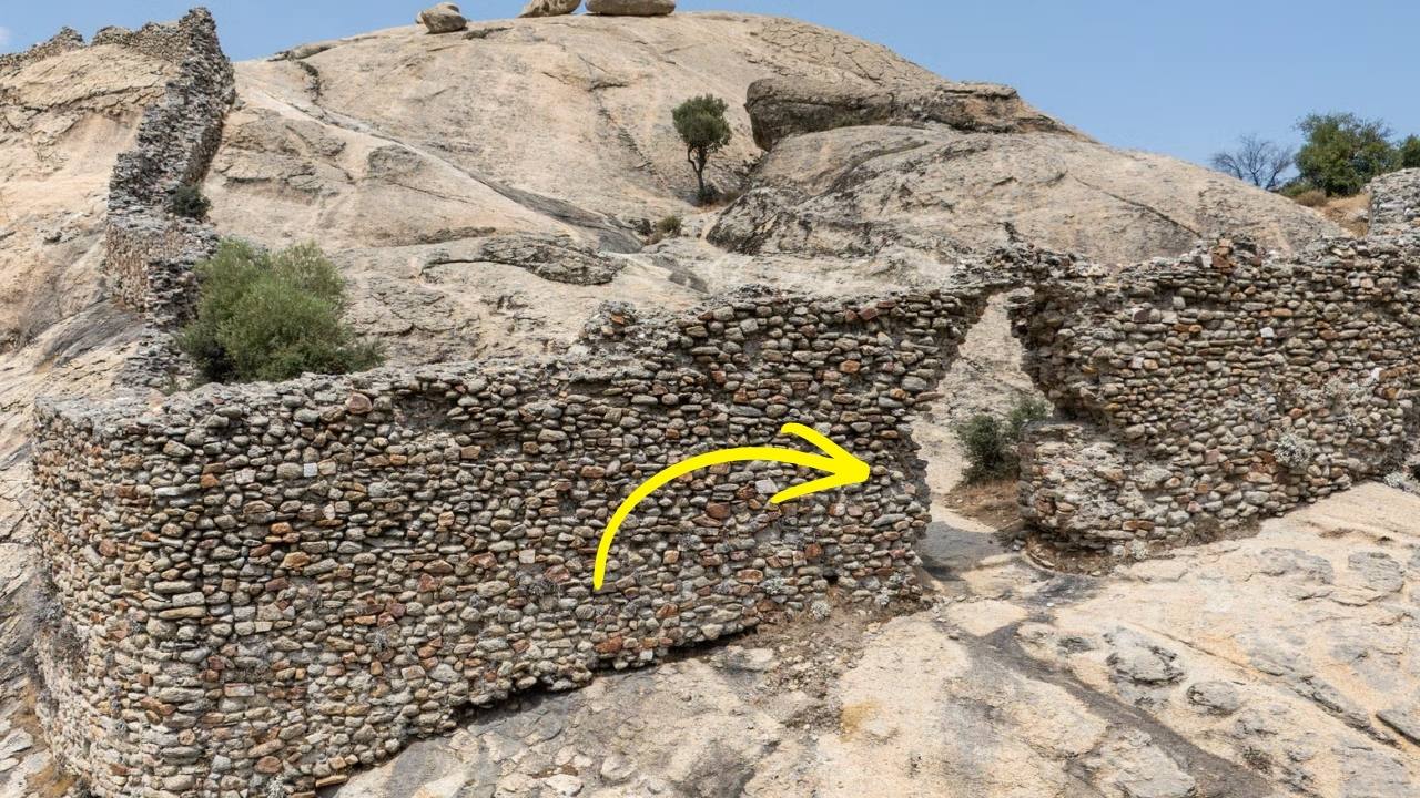
The discovery was officially confirmed by Panama’s Ministry of Culture (MiCultura) . Tomb 3 is located at the El Caño site in the district of Natá de los Caballeros, approximately 200 kilometers southwest of Panama City . The site has been under systematic investigation for nearly two decades, funded by the Ministry in collaboration with the Fundación El Caño .
Interestingly, Tomb 3 was first identified way back in 2009 . Archaeologists noticed a high concentration of ceramic materials and metal fragments in the area. But the full structure remained hidden, tantalizingly out of reach. It was only during the 2026 excavation season that the team, led by project lead archaeologist Julia Mayo, finally uncovered its complete form .
What they found exceeded all expectations.
The tomb dates to between 800 and 1000 AD , a period when complex societies flourished across Panama’s central provinces. It contains multiple human remains, arranged in a deliberate, meaningful pattern. At the center lies the principal individual, laid out in an extended position. Surrounding him are other individuals and a breathtaking array of offerings .
What the Golden Offerings Reveal: Power Clad in Gold
The central individual was buried with objects that speak unmistakably of elevated social rank. Archaeologists recovered gold pectorals, earrings, and bracelets. Some of these ornaments are decorated with iconography representing bats and crocodiles—motifs deeply rooted in local artistic traditions and associated with power, the underworld, and transformation .
Julia Mayo explained the clear hierarchy: “The individual with the gold was the one with the highest social status in the group.” In death, as in life, his status was unmistakable.
But the metal objects are more than just beautiful. They demonstrate advanced metallurgical knowledge and access to valuable resources. Such items were not mere decoration. They were powerful symbols of authority, reinforcing elite status within the community both in life and in death. To be buried in gold was to declare one’s rank for eternity.
The Broader Context: A Regional Network of Power
El Caño has long been recognized as a major pre-Hispanic cemetery, functioning as a ceremonial center for roughly 200 years . To date, at least nine similar tombs have been discovered at the site . Tomb 3 expands this funerary record and offers fresh data for understanding political authority, ritual practices, and long-distance trade networks during a peak period of sociopolitical development.
Particularly significant are the stylistic and technological similarities between artifacts recovered at El Caño and those found at Sitio Conte, another major archaeological site in Coclé province . These parallels strengthen the hypothesis that communities in the region shared a common cultural tradition and maintained close political and economic ties.
This was not an isolated society. El Caño was part of a broader regional network of interaction and exchange. The gold, the ceramics, the symbols—all point to connections that stretched across the isthmus.
Global Implications: Rethinking Pre-Hispanic Leadership
From a scientific perspective, Tomb 3 provides critical evidence for reevaluating theoretical models about the emergence and consolidation of complex chiefdoms in the Isthmus of Panama. The scale and richness of the burial suggest centralized political structures capable of mobilizing labor, organizing elaborate ceremonies, and sustaining extensive exchange networks.
The spatial organization of the burial and the deliberate placement of bodies and objects reveal a sophisticated belief system. Experts emphasize that, for these societies, death was not viewed as an end but as a transition to another realm where social rank remained meaningful. The display of material wealth in the principal burial likely functioned as both a spiritual provision and a social statement—reinforcing the legitimacy and authority of ruling elites before the broader community.
By expanding the sample of known elite burials, Tomb 3 allows researchers to examine variability in funerary practices and possible changes over time. This new evidence will help refine chronologies and clarify how leadership structures evolved during a critical phase of regional history.
Cultural Heritage and National Identity: A Source of Pride
Beyond its academic value, the discovery carries significant cultural and educational importance for modern Panama. During a site visit, Panama’s Minister of Culture emphasized the government’s commitment to strengthening research and promoting El Caño as a center for investigation and public education .
Officials highlighted ongoing efforts to advance the El Caño Museum project, which aims to serve as a hub for research and learning for both Panamanians and international visitors interested in the country’s deep historical roots .
The Ministry described the discovery as “of great importance for Panamanian archaeology and the study of pre-Hispanic societies of the Central American isthmus” . By responsibly disseminating research findings, the project seeks to bring science closer to society and foster respect for archaeological heritage.
For local communities in Coclé, discoveries like Tomb 3 reinforce a sense of cultural identity and pride in a sophisticated ancestral past. The finely detailed goldwork and ceramics testify to advanced craftsmanship and artistic expression more than a millennium ago.
What This Means for History: The Story Continues
The excavation of Tomb 3 reaffirms the importance of sustained investment in archaeological research in Panama. Each newly uncovered context at El Caño contributes not only spectacular artifacts but also solid scientific knowledge about the societies that once inhabited the region .
As investigations continue, Tomb 3 stands as another chapter in an unfolding story—one that reveals the complexity, power, and enduring legacy of Panama’s pre-Hispanic civilizations.
The lord of El Caño was buried with gold and crocodiles, surrounded by his companions, honored with rituals that have echoed across a thousand years. Now, his story is finally being told. And the world is listening.
In-Depth FAQs: Your Questions Answered
1. Where is El Caño, and why is it important?El Caño is an archaeological site located in Panama’s Coclé province, about 200 kilometers southwest of Panama City . It was a major pre-Hispanic cemetery and ceremonial center that functioned for roughly 200 years, between the 8th and 11th centuries AD . The site is known for its elite burials, which contain rich gold offerings and provide crucial evidence for understanding the complex chiefdoms that flourished in the region .
2. What was found in Tomb 3?Tomb 3 contained multiple human remains arranged around a central individual of high status. This principal person was buried with elaborate gold ornaments, including pectorals, earrings, and bracelets decorated with bat and crocodile iconography . The tomb also contained finely crafted ceramics and other offerings, indicating a sophisticated belief system and clear social hierarchy .
3. Who was the person buried with the gold?Archaeologists believe the central individual was a high-status leader or chieftain within the local society. Project lead Julia Mayo stated: “The individual with the gold was the one with the highest social status in the group” . The richness of the burial goods and the presence of accompanying individuals confirm his elevated rank.
4. What do the bat and crocodile symbols mean?Bats and crocodiles are motifs associated with local artistic traditions and likely held deep symbolic meaning. Bats, which inhabit caves and emerge at night, are often linked to the underworld, transformation, and the passage between life and death. Crocodiles, as powerful apex predators, represent strength, authority, and connection to the watery realms. Together, they reinforced the spiritual and political power of the individual buried with them .
5. How does this discovery connect to other sites in Panama?The artifacts from El Caño show strong stylistic and technological similarities to those found at Sitio Conte, another major archaeological site in Coclé province . These parallels suggest that communities in the region shared a common cultural tradition and maintained close political and economic ties, forming part of a broader regional network of interaction and exchange .
]]>That is exactly what happened on a storm-battered beach in eastern Scotland. And only the sharp eyes of local dog walkers and the desperate race of archaeologists preserved a 2,000-year-old moment that would otherwise have been lost to the waves.
This is the story of the Angus Beach footprints—and the storm that nearly stole them.
The Astonishing Find: A Surface from the Past
The discovery began with erosion. Powerful storms battered the coast of eastern Scotland, eating away at the sands of Angus Beach. When the tides receded, they left behind something extraordinary.
An ancient clay surface lay exposed.
And on that surface were marks that stopped people in their tracks: footprints. Human footprints. Animal footprints. Preserved in the clay for two millennia, now revealed under grey Scottish skies.
Local dog walkers spotted the markings. They did exactly what needed to be done. They alerted Bruce Mann, the council archaeologist. Mann recognized the significance immediately. He called in a team from the University of Aberdeen.
Kate Britton, the team leader, described the urgency:
“We knew we were dealing with a really rare site and that this discovery offered a unique snapshot in time—but it was also clear that the sea would soon take back what had so recently been revealed.”
The clock was ticking.
What the Footprints Reveal: A Moment Frozen in Mud
The team raced against the elements. They mapped the site. They took physical casts of the prints. They captured 3D models using advanced scanning technology. Every second counted.
The prints told a story.
Barefoot humans walked here. Animals moved alongside them. The clay had been soft enough to capture every detail—toes, heels, the subtle pressures of living beings going about their day. Then the surface dried or was covered, sealing the moment for 2,000 years.
Who were these people? What were they doing? The footprints alone cannot say. But they offer something almost more intimate: direct evidence of presence. A man or woman walked here. A child may have run alongside. Animals grazed or were herded nearby.
This was not a battlefield or a royal tomb. It was a day in the life of Iron Age Scotland.
Dating the Moment: Plant Remains and Radiocarbon
To understand when this moment occurred, the team needed more than footprints. They needed datable material.
Beneath the layer of clay that held the prints, they found plant remains. These were carefully collected and sent for radiocarbon dating. The results confirmed the age: approximately 2,000 years old.
That places the footprints in the Iron Age, a period of significant change in Scotland. Iron tools were replacing bronze. Communities were building hillforts and brochs. The Romans were pressing northward, though they never conquered Caledonia.
The people who left these prints lived in that world. They knew nothing of the empire to the south. They knew their land, their animals, their coastline. And they walked here, leaving marks that would outlast them by two millennia.
The Race Against Destruction: 50-Mile-per-Hour Winds
The archaeologists worked under impossible conditions. The same storms that had revealed the site were now trying to destroy it.
Britton described the challenge:
“The sea would soon take back what had so recently been revealed.”
Tides washed in and out. Winds reached 50 miles per hour. The fragile clay surface crumbled. Each wave erased more of the prints. Each gust dried and cracked the ancient ground.
The team did not stop. They documented everything they could, as fast as they could. When the site finally vanished beneath the returning sand and sea, they had preserved it. The footprints were gone, but the data remained.
Global Implications: Community as First Responders
This discovery carries a powerful lesson. It was not an archaeologist who found the prints. It was not a university research project. It was local dog walkers who spotted something unusual and reported it.
Elinor Graham of the University of Aberdeen emphasized this point:
“With sea levels rising and coastal erosion accelerating around Scotland it’s more important than ever that local community members keep an eye on their local coasts and report potential new discoveries.”
Scotland’s coastline is eroding rapidly. Climate change accelerates the process. Ancient sites that have been buried for millennia are being exposed—and destroyed—at an unprecedented rate.
The people who walk these beaches every day are the first line of defense. Their eyes can spot what professionals might miss. Their reports can trigger the kind of rapid response that saved the Angus footprints.
This is citizen science in action. And it is saving history.
What This Means for History: Every Print Tells a Story
The Angus Beach footprints are now preserved digitally and in casts. They will be studied for years to come. But their true significance goes beyond the data they contain.
They are a reminder that history is not just in books and museums. It is in the ground beneath our feet. It is in the cliffs and beaches we walk every day. It is fragile, fleeting, and irreplaceable.
Two thousand years ago, someone walked here. Their feet pressed into wet clay. The sun dried it. Sediment covered it. Storms revealed it. And for a few precious days, before the sea reclaimed it, we saw their prints.
We saw them because dog walkers paid attention. Because archaeologists raced against the tide. Because technology captured what nature would soon erase.
The footprints are gone now. But their story remains.
And it is a story that belongs to everyone.
In-Depth FAQs: Your Questions Answered
1. How did footprints survive for 2,000 years on a beach?The footprints were made in wet clay that then dried or was quickly covered by sediment. This sealed the surface, protecting it from erosion and disturbance. Over millennia, additional layers built up on top, preserving the prints until recent storms stripped away the overburden and re-exposed the ancient ground surface.
2. How do we know the footprints are 2,000 years old?Archaeologists collected plant remains from directly beneath the footprint layer. These were analyzed using radiocarbon dating, which measures the decay of radioactive carbon in organic material. The results placed the plant remains, and therefore the overlying footprints, at approximately 2,000 years before present.
3. Who were the people who made the prints?The footprints themselves do not reveal identity, but the dating places them in the Iron Age in Scotland. This was a period when the local population lived in farming communities, built hillforts, and had limited contact with the Roman Empire to the south. They were likely part of the ancestral Celtic cultures of the region.
4. Why was it so urgent to document the site quickly?The site was exposed by storm erosion and remained vulnerable to tidal action and wind. The same forces that revealed it would soon destroy it. The team had a narrow window—measured in days—to record as much information as possible before the fragile clay surface was completely eroded.
5. What can we learn from footprints that we cannot learn from other artifacts?Footprints offer a direct, intimate connection to individual humans and animals. They show us movement, gait, group composition, and behavior. Unlike tools or pottery, which may be traded or moved, footprints are in situ—they record exactly where and how living beings passed through a landscape. They are moments frozen in time.
]]>The Dramatic Lift Operation
The operation unfolded over several tense days in early February 2026, involving cutting-edge cranes and divers working in murky depths.
Each stone, weighing as much as 15 elephants, was carefully hoisted from 30 feet underwater, revealing intricate carvings unseen for centuries.
Teams coordinated with precision to avoid damaging the fragile artifacts, using sonar mapping to pinpoint locations. Cheers erupted onshore as the first block broke the surface, dripping with seawater and history.
Local experts hailed it as a turning point for American archaeology, drawing parallels to famous underwater recoveries elsewhere.
Uncovering a Forgotten Wonder
These stones once formed part of a colossal lighthouse-like structure, built around 200 BCE by an unknown coastal culture.
Estimated at over 400 feet tall, it guided maritime trade along ancient Pacific routes, much like its famous counterparts.
Fragments include massive lintels, door thresholds, and paving slabs etched with symbols of sea voyages and celestial maps. One standout piece features a pylon doorway blending local motifs with influences from distant lands.
The site’s discovery began with sonar anomalies detected during a routine ocean survey, leading to dives that confirmed the ruins’ scale.
Challenges of the Deep-Sea Recovery
Lifting such behemoths posed enormous risks—currents, poor visibility, and structural instability threatened the mission. Engineers deployed custom slings and buoyancy aids to distribute weight evenly across the 80-tonne giants.
Over 22 blocks were recovered in total, each scanned on-site with 3D lasers for digital preservation. The process required international collaboration, blending American ingenuity with global expertise.
One diver recounted the eerie moment: “As the stone rose, schools of fish swirled around it like ghosts welcoming it back to the light.”
Echoes of Ancient Engineering
How did ancients maneuver these monsters without modern tech? Evidence suggests ramps, levers, and sheer manpower, possibly aided by tidal assistance in shallow bays.
The stones’ precision-cut joints—gaps too tight for a razor blade—hint at lost techniques using abrasives and patience. Comparisons to other megalithic feats worldwide underscore the sophistication.
This recovery fuels debates on pre-Columbian trans-Pacific contacts, with motifs resembling Asian designs sparking lively academic discourse.
Digital Rebirth of the Monument
Now safely ashore, the stones feed into Project PHARUS, creating a virtual twin of the original structure. High-res scans allow experts to “rebuild” it digitally, testing theories on its collapse from earthquakes around 1300 CE.
Public VR tours are planned, letting anyone explore the beacon’s heights. Funding from private tech donors accelerates this immersive revival.
The effort promises to rewrite coastal history books, proving advanced societies thrived here long before European arrival.
Implications for U.S. Heritage
This find elevates America’s archaeological profile, positioning it alongside global icons. Preservationists push for a new national underwater park to protect remaining ruins.
It challenges old narratives, suggesting robust trade networks linked ancient Americas to broader worlds. Schools nationwide are incorporating the story into curricula.
Local communities celebrate their ancestral ties, with indigenous groups consulted on interpretations.
Broader Mysteries Revealed
The lift exposed metal fixings—bronze and lead—used in assembly, rare for the era and hinting at metallurgical prowess. Statues and tools dredged up add layers to the puzzle.
Climate data from stone algae suggests the site sank due to subsidence, not just quakes. Ongoing analysis could link it to regional seismic patterns.
Experts anticipate more lifts, with plans for 50 additional blocks by summer.
Voices from the Team
Lead archaeologist Dr. Elena Vasquez called it “a handshake with the past.” “These stones whispered secrets for millennia; now they’re shouting,” she said post-lift.
Crew members shared tales of near-misses, like a snapped cable during a swell, underscoring human grit behind the tech.
Archaeologists Lift 80-Tonne Stones
This monumental lift not only rescues history from oblivion but ignites wonder about our shared past. As digital models bring the lighthouse to life, it reminds us: America’s ancient stories are just beginning to surface, promising revelations for generations ahead.
FAQ
Q: How were the 80-tonne stones lifted? A: Specialized cranes with buoyancy aids and slings handled the weight, guided by divers and sonar.
Q: What caused the structure to sink? A: Likely earthquakes and land subsidence around 1300 CE, per initial studies.
Q: Is public access planned? A: Yes, VR experiences launch this spring, with a potential visitor center.
Q: Any human remains found? A: Not yet, but smaller artifacts like tools were recovered alongside stones.
Q: What’s next for the project? A: More lifts, full digital reconstruction, and genetic analysis of attached organics.
]]>That’s exactly what happened when archaeologists uncovered what they’re calling the Lost City of Alexander in the rugged heartland of the United States, rewriting pages of history we thought we knew.
A Discovery That Shook the World
It started with a hunch. A team of independent researchers, led by Dr. Elena Vasquez, a tenacious archaeologist from the University of Chicago, was surveying remote canyons in the American Southwest during a routine grant-funded expedition in late 2025.
What they found buried under layers of dust and rock wasn’t just pottery shards or arrowheads—it was a sprawling urban complex with unmistakable Hellenistic fingerprints.
Greek-style columns peeked from the earth, alongside coins bearing the profile of a youthful conqueror who could only be Alexander the Great.
The site, dubbed “Alexandria Occidental” by the team, spans over 200 acres, featuring grand boulevards, aqueduct remnants, and a massive central agora.
Vasquez recalls the moment vividly: “We were using ground-penetrating radar when the screen lit up like a Christmas tree.
Walls, temples, even a harbor basin adapted to a dried-up riverbed. This wasn’t Native American or Spanish— this screamed Macedonia.”
Word spread fast. By early 2026, as President Trump’s administration touted American exceptionalism, the discovery hit national headlines.
CNN aired drone footage showing the site’s scale, while Fox News hailed it as “proof of Western roots deeper than we imagined.”
The Man Behind the Mystery
Alexander the Great didn’t just conquer lands; he planted cities like seeds across his empire. History books list over 70 Alexandrias from Egypt to India, but whispers in ancient texts hinted at voyages beyond the known world.
Greek historian Strabo mentioned sailors pushed west by storms, and Ptolemaic maps sketched vague outlines of a “great western sea.”
Could Alexander’s fleets, fresh from Persian triumphs, have ventured across the Atlantic? Recent carbon dating places the site’s primary construction around 320 BCE, aligning perfectly with Alexander’s final years.
Dr. Vasquez’s team pieced together a narrative from artifacts: amphorae for olive oil, terracotta figurines of Heracles, and inscriptions in faded Koine Greek praising “the son of Zeus.”
One shattered stele reads, “To Alexander, founder of the eternal port,” etched in letters matching those from Alexandria in Egypt. This wasn’t a colony of later Greeks; the stratigraphy screams original expedition.
Skeptics argued migration or trade, but DNA from skeletal remains tells a different story. Preliminary analysis shows a mix of Macedonian, Persian, and local genomes, suggesting settlers intermarried but retained Old World customs. “These people brought their gods, their gymnasiums, their phalanxes,” Vasquez said in a press conference.
Unearthing the City’s Secrets
Excavations ramped up in January 2026, despite harsh winter winds. The team uncovered a theater seating 5,000, its stage adorned with marble masks of Dionysus.
Nearby, a gymnasium complex boasted palaestra courts for wrestling, echoing the training grounds of Pella. But the crown jewel? A towering lighthouse-inspired structure, possibly a pharos guiding ships up the ancient river now called the Forgotten Fork.
Workshops brimmed with iron slag and pottery kilns, evidence of a thriving economy. They smelted local copper into bronze statues, traded beads with indigenous tribes, and cultivated olives in terraced groves—miracles in the arid soil. Floods and quakes buried the city by 100 CE, leaving it lost until now.
Local ranchers had long shared tales of “Greek ghosts” in the canyons, dismissing them as folklore. One old-timer, Jake Harlan, grinned during a site visit: “My grandpappy said the rocks whispered in tongues. Turns out he was right.” The find has sparked tourism, with guided tours already booked through 2027.
Theories That Challenge Everything
How did they get here? Theory one: Post-Alexander fleets, displaced by storms, followed ocean currents to the Gulf of Mexico, then trekked north. Oceanography backs this— the North Atlantic Gyre could ferry ships in months.
Theory two: A deliberate exploratory armada, Alexander’s dream of encircling the world. Fragments of papyrus logs describe “endless waters and feathered men,” hinting at New World encounters.
Critics point to Phoenician navigators in Alexander’s navy, masters of the seas who mapped Africa. “If they hugged Gibraltar, why not push further?” posits maritime historian Dr. Liam Ford. Radiocarbon on ship timbers matches Macedonian pine.
This upends transatlantic contact timelines, predating Vikings by 1,400 years. “Columbus wasn’t first,” Vasquez declares. “Alexander’s shadow reached America.”
Rewriting American Origins
The implications ripple wide. Museums clamor for artifacts; the Smithsonian plans a blockbuster exhibit. Educational curricula may shift, adding Hellenistic chapters to U.S. history.
Native American partnerships ensure respectful digs, with tribes consulted on sacred sites overlapping the ruins.
Economically, it’s a boon. Nearby towns buzz with jobs, hotels sprout like wildflowers. President Trump tweeted: “America’s history just got greater—Alexander knew a winner when he saw one!”
Challenges loom: Looting risks, preservation funding, academic turf wars. But the site’s resilience—surviving millennia underground—inspires hope.
Key Discoveries Table
Artifact CategoryDescriptionSignificance Coins & Inscriptions50+ silver tetradrachms with Alexander’s image; Greek stelesDirect link to 4th century BCE MacedoniaArchitectureColumns, agora, theater; 8m wallsUrban planning identical to eastern AlexandriasTools & TradeBronze tools, amphorae, beadsEvidence of industry and indigenous exchangeHuman Remains20 skeletons with hybrid DNAProof of settlement and interminglingHydraulicsAqueducts, cisternsAdvanced engineering in desert environment
SCIENCE MARVELS – READ MORE : NASA’s ‘Missing’ Moon Mystery Explained: Scientists Uncover Shocking New Clues in Lunar History and Space Formation Discoveries
Lost City of Alexander
This Lost City of Alexander doesn’t just fill a historical blank; it bridges worlds, proving ambition knows no ocean. As digs continue, expect more revelations that humble our maps and exalt human reach. The past isn’t buried—it’s rising, one stone at a time.
FAQ
Q: When was the city founded?A: Around 320 BCE, during Alexander’s late campaigns.
Q: How was it discovered?A: Ground-penetrating radar and drone surveys in 2025.
Q: Is this confirmed as Alexander’s?A: Artifacts and dating strongly suggest yes, pending peer review.
Q: What’s next for the site?A: Full excavations, museum exhibits, and tribal collaborations.
Q: Does this change world history?A: Absolutely—earliest proof of Old World contact with America.
]]>For 12,000 years, people came here. They painted on its walls. They built fires in its chambers. They sheltered their families and their livestock. They left their marks in pigment, in stone, in pottery, and in prayer. Now, for the first time, the Um ‘Irak Plateau is speaking. And its voice echoes across millennia.
This is the story of the most important archaeological discovery in Sinai in decades.
The Astonishing Find: A Shelter Longer Than a Football Field
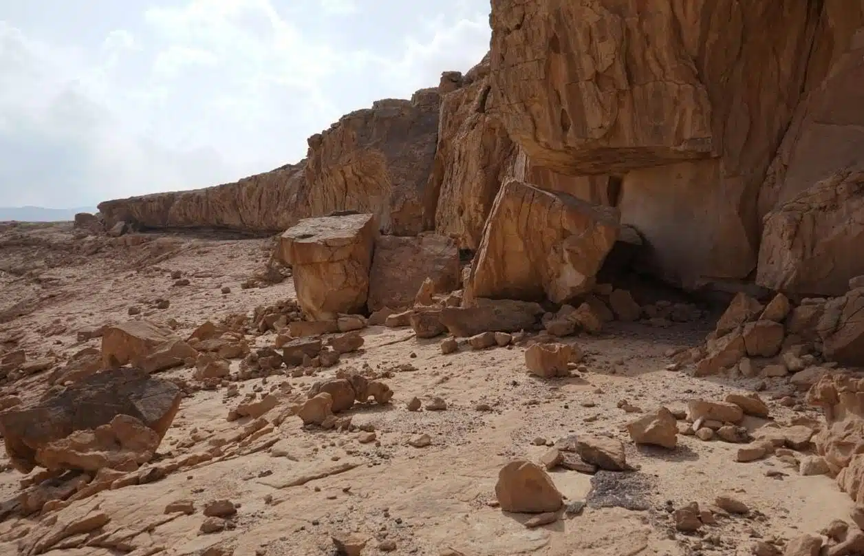
The discovery came during routine survey work by Egypt’s Supreme Council of Antiquities. The team was documenting a remote desert area. They had no idea what lay ahead.
Then they found the wall.
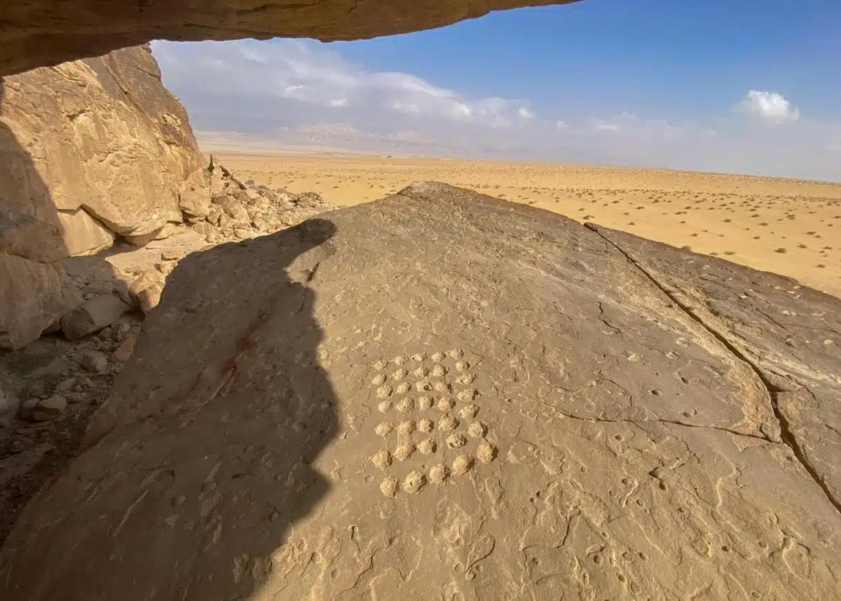
A natural sandstone rock shelter stretches for more than 100 meters—longer than a football field—along the eastern side of the plateau. Its overhanging ceiling provided shade and protection. Its floor offered space for habitation. Its walls became canvases.
What the team found inside is nothing short of revolutionary.
What the Paintings Reveal: Art Across 10,000 Years
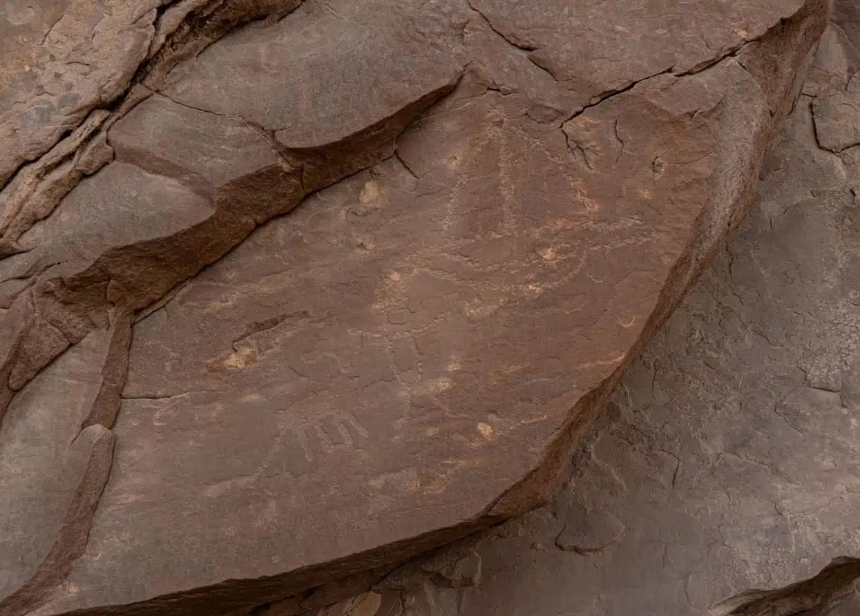
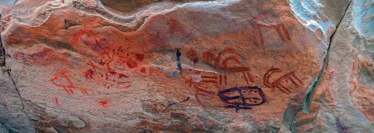
The ceiling of the shelter is covered in paintings. Red pigment, applied by human hands thousands of years ago, depicts animals and symbolic forms. Researchers tentatively date these images to between 10,000 and 5,500 BC. These are among the oldest known artistic expressions in the region.
But the art does not stop there.
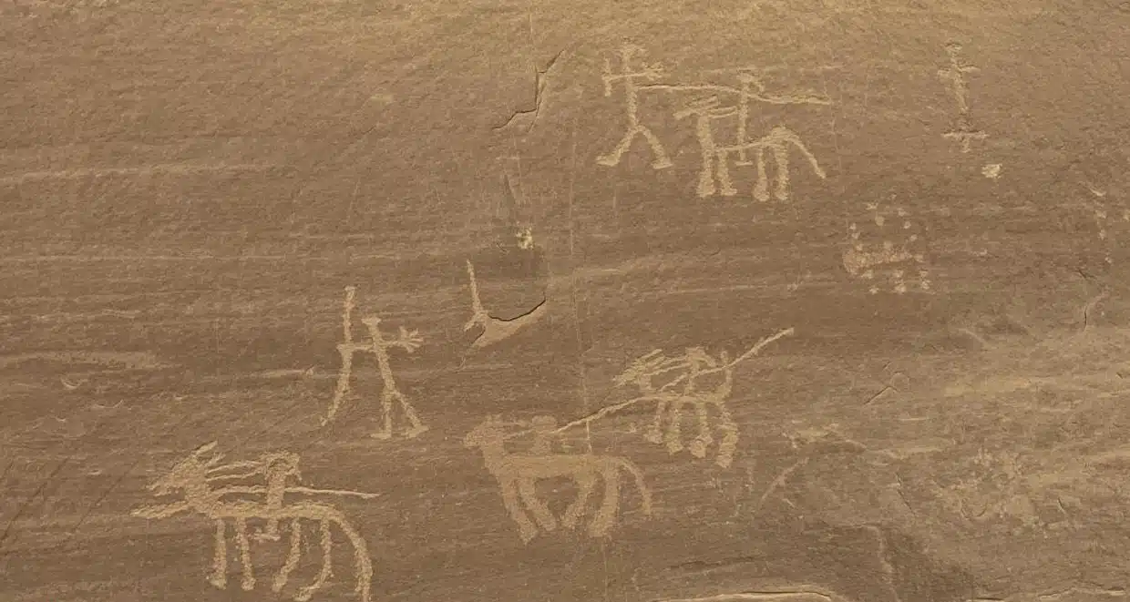
Archaeologists documented a separate group of drawings made in gray pigment, recorded here for the first time anywhere. Shallow relief engravings show hunting scenes—archers pursuing ibex, accompanied by dogs. The compositions are dynamic. They capture movement, skill, and the daily struggle for survival.
These images are not mere decoration. They are records of life.
They show what people valued, what they feared, what they celebrated. The hunters, the ibex, the dogs—these were the realities of existence in prehistoric Sinai. The artists who carved them into stone were telling their own stories, preserving their world for posterity.
Evidence of Long-Term Occupation: A Home for Millennia
The paintings alone would make this site significant. But the Um ‘Irak Plateau offers far more.
Inside the shelter, archaeologists found clear signs of repeated human use. Stone partitions divide the space into separate living areas. At the center of several compartments, layers of ash and charcoal mark ancient hearths. Fires burned here, generation after generation.
The floor holds animal droppings, thickly deposited. Later inhabitants used the shelter not only for themselves but for their livestock. They adapted the space for survival, seeking protection from rain, wind, and the bitter cold of desert nights.
This was not a temporary campsite. This was a home.
What the Artifacts Reveal: Pottery Across Empires
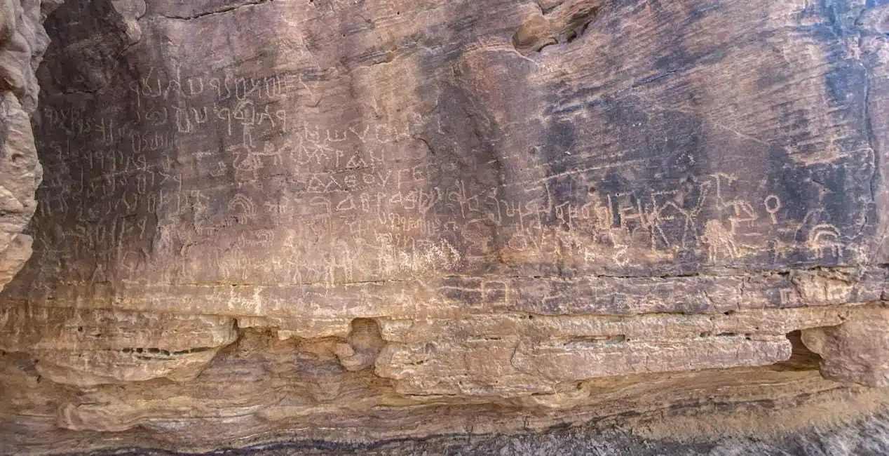
Survey work across the plateau yielded flint tools and pottery sherds in staggering numbers. The ceramics tell a story of continuous occupation spanning major eras of Egyptian history.
Some fragments date to Egypt’s Middle Kingdom (circa 2055–1650 BCE). Others belong to the Roman period, including examples from the third century AD. The site was not abandoned when the pharaohs fell. It remained in use, adapting to new rulers, new cultures, new worlds.
Later carvings depict camels and horses. Armed riders appear alongside Nabataean inscriptions, pointing to periods of trade and cultural exchange. The Nabataeans, master traders of the ancient world, left their mark here. Arabic inscriptions provide evidence of continued use during early Islamic periods and beyond.
The shelter became a palimpsest—a surface written upon again and again, each generation adding its own chapter.
Global Implications: Sinai as a Crossroads of Civilizations
The Um ‘Irak Plateau lies approximately 5 kilometers northeast of the Temple of Serabit el-Khadim, near ancient copper and turquoise mines. Its elevated position overlooks a wide expanse stretching north toward the Tih Plateau. This was not a random gathering place. It was strategic.
Researchers believe the plateau served multiple roles over time: a lookout point, a gathering place, a rest stop for travelers moving through the region. Its location along ancient mining routes made it a natural hub. People passed through. Some stayed. Many left their names, their prayers, their art.
This discovery transforms our understanding of Sinai. The peninsula was not merely a corridor between Africa and Asia. It was a destination, a place where people lived, worked, and expressed themselves for over ten millennia.
Egypt’s Minister of Tourism and Antiquities, Sherif Fathy, described the find as a major addition to Egypt’s archaeological record. It strengthens understanding of Sinai’s role as a crossroads of civilizations. It also enhances Egypt’s position on the global cultural tourism map.
What This Means for History: An Open-Air Museum of Human Expression
Hisham El-Leithy, secretary-general of the Supreme Council of Antiquities, called the plateau one of the most important rock art sites identified in recent years. The wide range of artistic styles and inscriptions transforms the site into an open-air museum documenting the evolution of human expression from prehistoric times through the Islamic periods.
This is not hyperbole. The site preserves:
- Prehistoric paintings from 10,000–5,500 BC
- Hunting scenes in shallow relief
- Middle Kingdom pottery
- Roman-era ceramics
- Nabataean inscriptions
- Early Islamic Arabic texts
Each layer adds depth to our understanding of human history. Each mark on the wall represents a moment of connection—between artist and material, between individual and community, between past and future.
The Path Forward: Preservation and Community
Mohamed Abdel-Badei emphasized that the discovery is part of ongoing efforts to survey and document rock art across South Sinai. Local cooperation plays a key role. Residents of the Serabit el-Khadim area have supported the work, helping protect cultural heritage that belongs to all humanity.
Further scientific analysis is underway. Researchers aim to refine dating, study artistic techniques, and develop a long-term preservation plan. The Um ‘Irak Plateau must be protected for future generations. Its walls hold stories that cannot be replaced.
Twelve thousand years of human history, preserved in a single shelter. The people who painted those walls could never have imagined that their marks would endure so long. They could not have known that one day, archaeologists would stand where they stood, tracing their lines with wonder.
But they must have hoped. Why else would they have bothered?
They painted for themselves, for their communities, for the spirits they honored. But they also painted for us. They reached across time, leaving messages in red pigment and shallow relief. And now, at last, we are reading them.
In-Depth FAQs: Your Questions Answered
1. How old are the oldest paintings at Um ‘Irak?Researchers tentatively date the earliest red-pigment paintings to between 10,000 and 5,500 BC. This places them in the Epipaleolithic period, a transitional era when hunter-gatherer societies in the region began developing more complex social structures and artistic traditions. Further analysis may refine this dating.
2. What do the hunting scenes show?The shallow relief engravings depict hunters using bows to pursue ibex, accompanied by hunting dogs. These scenes provide direct evidence of hunting techniques, social organization, and the relationship between humans and animals in prehistoric Sinai. The dynamic compositions suggest skilled observation of animal behavior.
3. Who were the Nabataeans, and why are their inscriptions here?The Nabataeans were an ancient Arab people who controlled trade networks across the Arabian Peninsula and Levant from roughly the 4th century BCE to the 2nd century CE. Their capital was Petra in modern Jordan. Their inscriptions at Um ‘Irak indicate that the site lay along or near their trade routes, serving as a waypoint for caravans moving through Sinai.
4. Why was this site used for so long?The natural rock shelter offered essential protection from harsh environmental conditions—rain, wind, and cold. Its location near ancient mining routes and overlooking a wide area made it strategically valuable. The availability of water sources, now possibly dried, would have supported repeated occupation. Each culture that passed through recognized its utility and significance.
5. What happens to the site now?The Supreme Council of Antiquities, in collaboration with researchers, is developing a long-term preservation and documentation plan. Further scientific analysis will refine dating and study artistic techniques. Community involvement with local residents will help protect the site. There is potential for the Um ‘Irak Plateau to become a protected archaeological park, showcasing Sinai’s unparalleled heritage as a crossroads of civilizations.
]]>
Deep in modern-day Iraq, researchers have finally pinpointed the location of Charax Spasinou—the Alexandria on the Tigris. This is the story of how drone technology, magnetometers, and sheer determination pulled a 2,300-year-old secret from the sand.
The Astonishing Find: A City Built by a Legend
The year was 324 BCE. Alexander the Great was at the height of his power. His armies had swept across Persia. Egypt had fallen. The known world lay at his feet. During this final chapter of his life, he ordered the foundation of a new city.
It would be called Alexandria.
But not the famous Alexandria in Egypt. This was Alexandria-on-the-Tigris, established in what is now southern Iraq. Alexander populated it with veteran soldiers and settlers from a destroyed nearby town. It was meant to be a stronghold, a trading hub, a beacon of Greek culture in Mesopotamia.
Then, Alexander died. The city’s fate became entangled in history.
Pliny the Elder, the Roman author, recorded its turbulent story in his Naturalis Historia. The original Alexandria was destroyed by floods. A Seleucid king named Antiochus rebuilt it, renaming it Antioch. More floods came. Finally, a local ruler named Spaosines restored it once more, building massive embankments to tame the rivers. He gave it his own name: Charax Spasinou.
The city survived for centuries. It became a wealthy trading hub. And then, it vanished.
The Century-Long Hunt
For generations, historians and archaeologists debated its location. They had Pliny’s description: a city on an artificial elevation, between the Tigris and another river, at their junction. But rivers change course. Landscapes shift. The precise spot remained elusive.
In the 1960s, a British researcher named John Hansman examined Royal Air Force aerial photographs. He spotted something intriguing: a huge walled enclosure and traces of settlement in the region. It was a promising lead. But he could not follow it.
Geopolitics intervened.
Decades of conflict in Iraq made on-the-ground research impossible. The site, whatever and wherever it was, remained out of reach. The lost city waited.
What the New Surveys Reveal: Technology Breaks the Deadlock
In 2014, conditions finally allowed access. A research team moved in to conduct large-scale surface surveys. They walked across more than 500 square kilometers. They recorded dense scatters of pottery, brick fragments, and industrial debris. The surface was speaking. They were listening.
Then came the drones.
Thousands of aerial photographs built a detailed terrain model. Every bump and shadow was mapped. Next, geophysicists deployed magnetometers. These instruments measure subtle variations in the Earth’s magnetic field. Buried walls, kilns, and foundations distort that field. The magnetometers revealed what lay beneath.
The result was astonishing.
The outline of a complete city emerged from the data. Wide streets formed a grid. Large housing blocks stretched across the urban plan. Temple compounds sat within walled precincts. Workshops with kilns indicated industrial activity. Canals connected to the river. Harbor basins marked the waterfront.
Charax Spasinou had been found.
Global Implications: Rewriting Mesopotamian Trade
The city’s location along the Tigris was strategic. It sat at a crossroads of ancient trade routes. Goods from the Persian Gulf could move upriver. Caravans from Arabia could reach its markets. Products from the Mediterranean could flow through.
This was a hub of commerce.
The newly revealed street grid and harbor infrastructure confirm its economic importance. The city was designed for movement, for exchange, for prosperity. It connected Mesopotamia to the wider Hellenistic world and beyond.
The team now hopes to determine the city’s construction phases. They want to link its urban growth with shifts in trade and environmental change. When did it flourish? When did it decline? How did the rivers shape its fate?
What This Means for History: Excavations Await
For now, the city remains buried. The surveys have mapped it. The mystery of its location is solved. But the real work is just beginning.
The research team hopes to secure permission for full-scale excavations. They want to uncover the streets, the temples, the homes of Alexander’s veterans. They want to walk where Spaosines built his embankments. They want to touch the bricks of a city that rose from floods and survived for centuries.
Charax Spasinou is one of Alexander’s last works. It was founded as he raced toward the end of his life. It witnessed the rise and fall of empires. It was lost, and now it is found.
The desert kept its secret for 1,200 years. Not anymore.
In-Depth FAQs: Your Questions Answered
1. How was the city finally located after so many years of searching?The breakthrough came from a combination of non-invasive survey techniques. Researchers conducted extensive surface walking to collect pottery and debris. They used drone photography to create high-resolution terrain models. Most importantly, they deployed magnetometers, which detect buried structures by measuring magnetic field distortions. This multi-layered approach revealed the city’s grid, buildings, and infrastructure without digging a single shovel.
2. Why does the city have three different names?Each name marks a distinct phase in its history. Alexandria was the original name given by Alexander the Great. After destruction by floods, the Seleucid king Antiochus rebuilt it and renamed it Antioch. Following another flood, the local ruler Spaosines restored it once more, built protective embankments, and renamed it Charax Spasinou—”Charax” meaning fortress or enclosure, and “Spasinou” referring to Spaosines himself.
3. What role did Pliny the Elder play in finding the city?Pliny the Elder’s Naturalis Historia, written in the first century CE, provided the essential literary description of the city’s location. He placed it on an artificial mound between the Tigris and Eulaeus rivers at their junction. While not precise enough for GPS coordinates, his account gave researchers a general region to investigate and confirmed the city’s historical existence and significance.
4. Was this city important in the ancient world?Absolutely. Charax Spasinou became a major trading hub in Mesopotamia. Its position along the Tigris connected it to the Persian Gulf and the Indian Ocean trade. It handled goods traveling between the Roman Empire, Parthia, India, and Arabia. Its wealth and strategic importance made it a coveted prize for successive empires.
5. Will archaeologists actually dig up the city?The research team hopes to conduct future excavations pending permits and funding. The magnetometer and drone surveys have provided a detailed map of what lies beneath. Excavations would allow archaeologists to recover artifacts, date construction phases, and understand daily life in the city. For now, the site is protected and documented, awaiting the next phase of discovery.
]]>The findings are being hailed as a major breakthrough in understanding early human behavior, intelligence, and technological skill during the Middle Pleistocene era.
Ancient Wooden Tools Unearthed in Greece
The discovery comes from the Marathousa 1 archaeological site in Greece’s central Peloponnese, a location long known for its exceptional preservation conditions. Researchers uncovered two carefully worked wooden artifacts—one made from alder wood and another from either willow or poplar—both dating back approximately 430,000 years.
These tools were identified and analyzed by an international research team from the University of Tübingen and the University of Reading, with the study published in the prestigious journal PNAS.
Microscopic Proof of Human Craftsmanship
Unlike stone tools, wooden objects rarely survive for hundreds of thousands of years due to natural decay. According to Annemieke Milks, an expert in early wooden technologies at the University of Reading, the survival of these tools is extraordinary.
Using microscopic analysis, researchers examined the surface of the wooden remains and identified clear marks from chopping and carving. These marks provide unmistakable evidence that early humans deliberately shaped the wood rather than using it in a natural or accidental form.
The analysis confirmed that two of the wooden pieces were intentionally modified by humans, while a third piece initially examined was later determined to have been marked by animal claws rather than human hands.
A Window Into Middle Pleistocene Life
Marathousa 1 was once located along the shore of a prehistoric lake and appears to have been a crucial hub for human activity during the Middle Pleistocene period, which lasted from around 774,000 to 129,000 years ago. Alongside the wooden tools, archaeologists discovered stone tools, bone artifacts, and the remains of an elephant and other animals.
These findings suggest that the site served as a butchering and processing area where early humans exploited both animal and plant resources. The presence of large animal remains alongside tools highlights a sophisticated understanding of survival strategies.
Expanding the Known Limits of Early Technology
One of the alderwood tools showed signs of heavy use, suggesting it played an important role in daily activities. Researchers believe it may have been used for digging near the lakeshore, extracting roots, or stripping bark from trees. The second tool, a much smaller piece of willow or poplar, appears to have been shaped for fine tasks and may have been used in the production or maintenance of stone tools.
This smaller artifact is especially significant, as it represents a uniquely compact, likely finger-held wooden tool—something rarely seen in the archaeological record from this period. Together, the tools demonstrate that early humans were not only using large, simple implements but were also capable of producing specialized wooden tools for different purposes.
Competition With Carnivores and Complex Behavior
According to paleoanthropologist Katerina Harvati, who leads the long-term research program at the site, the Middle Pleistocene was a critical phase in human evolution. It was during this time that more complex behaviors and advanced technological practices began to emerge.
The site also shows evidence of intense competition between humans and large carnivores. Marks left by predators were found near the butchered elephant remains, indicating that humans and carnivores were vying for the same food resources—a powerful insight into survival pressures faced by early humans.
Why This Discovery Changes Everything
Previous discoveries of ancient wooden objects—such as a 476,000-year-old wooden structure found at Kalambo Falls in Zambia—were not tools but structural elements. While wooden weapons and digging sticks have been found in places like the UK, Germany, China, and Zambia, all of those examples are significantly younger than the Marathousa 1 tools.
This makes the Greek discovery the earliest confirmed evidence of deliberate wooden toolmaking in human history and the first of its kind from southeastern Europe.
As researchers continue excavations, the Marathousa 1 site is expected to yield even more insights into how early humans adapted, innovated, and survived in challenging environments—reshaping what we know about the origins of human technology.
]]>Following a tip about looters—a modern crime yielding an ancient miracle—archaeologists have unveiled a Zapotec tomb of such breathtaking preservation that Mexico’s President has declared it “the most significant archaeological discovery of the last decade.” Dated to 600 AD, this isn’t a ruin. It’s a time capsule with its paint still wet, its carvings still sharp. It offers a direct, unfiltered conversation with the “Cloud People,” allowing us not just to study their death rituals, but to witness the profound artistry and spiritual conviction with which they honored the journey into the afterlife.
The Astonishing Find: A Perfectly Preserved Universe
The tomb’s power lies in its completeness. While many Mesoamerican tombs have been plundered or decayed, this one presents an intact narrative.
The Guardians at the GateThe entrance is commanded by potent symbolism. A sculpted owl—the Zapotec emissary of night and death—presides over the threshold. Beneath its gaze, vibrant murals depict a solemn procession of figures bearing copal resin, the sacred incense that bridged the earthly and divine realms. This isn’t mere decoration; it’s a choreographed ritual frozen in time, illustrating the continuous veneration that followed burial.
A Palette Defying CenturiesThe survival of the color palette is a scientific and aesthetic marvel. The ochres, whites, greens, and reds on the walls have not dimmed. This offers an unparalleled opportunity for conservators and chemists to analyze ancient pigments and for visitors to experience the aesthetic world of the Zapotec exactly as they intended it—vivid and spiritually charged.
The Deeper Meaning: More Than a Tomb
President Sheinbaum’s designation is not hyperbole. This tomb is a keystone discovery.
A Rosetta Stone for RitualThe clarity of the iconography—the owl, the procession, the architectural layout—acts as a “Rosetta Stone” for interpreting more fragmentary Zapotec sites. It provides the definitive context for understanding how ritual space was conceived, used, and experienced. It moves theory into the realm of witnessed practice.
The Heart of the Zapotec WorldviewThe tomb reinforces that for the Zapotec, death was not an end but a transition to ancestral status. This space was likely a site of ongoing ceremony, where the living returned to commune with and nourish the deified dead. It embodies the core Mesoamerican belief in a cyclical cosmos where ancestors actively influenced the world of the living.
Your Journey to the
For the history-inspired traveler, this discovery elevates Oaxaca from a destination to a pilgrimage. The new tomb is the dazzling centerpiece of a region that is essentially an open-air museum of Zapotec and Mixtec civilization.
The Archaeological Circuit:
- Monte Albán: The majestic hilltop capital, a UNESCO site offering panoramic views and the grand scale of Zapotec power.
- Mitla: The “Place of the Dead,” renowned for its incredibly intricate geometric stone mosaics, showcasing a later, unique architectural style.
- Yagul & Lambityeco: Smaller but profound sites featuring tombs, ball courts, and residential complexes that round out the picture of daily and ceremonial life.
The Cultural Context:
- Oaxaca City: Use the city as your base. Visit the Museo de las Culturas de Oaxaca (housed in a stunning ex-convent) and the Rufino Tamayo Museum of pre-Columbian art to see artifacts that provide further context before you visit the sites.
- Culinary & Craft Legacy: The Zapotec mastery of their environment lives on in Oaxaca’s world-famous cuisine (mole, chocolate) and vibrant artisan traditions (pottery, textiles). Engaging with these is part of understanding the enduring cultural legacy.
Traveling with Wisdom:As with many places of deep beauty, travel should be informed. The U.S. State Department advises increased caution (Level 2) for Oaxaca state due to crime in certain areas. However, the main tourist and archaeological corridors are generally safe with common-sense precautions:
- Stay Centered: Base yourself in well-trafficked areas like Oaxaca City’s historic center.
- Travel Smart: Use authorized taxi services or pre-booked tours for site visits. Travel between sites during daylight hours.
- Be Prepared: Keep digital copies of documents, stay hydrated with bottled water, and invest in a good guide—both a book and a knowledgeable local one.
The Final Verdict: A Must-See for the Historically Curious
The discovery at San Pablo Huitzo is a rare gift. It is a chance to stand before a chapter of human history that has not been rewritten by time or treasure hunters. While public access to the tomb itself will be highly controlled to ensure its preservation (with digital reconstructions likely being the primary public interface), its discovery fundamentally enriches a visit to Oaxaca.
To walk the plaza of Monte Albán now, knowing the vivid, intimate details of the belief system that powered it, is to transform that experience. This tomb doesn’t just add a new site to the map; it illuminates the entire region with a brighter, more detailed light. It affirms that the greatest journeys are those that connect us not just to a place, but to the profound human stories etched into its very foundation.
]]>The only building he explicitly claimed to have constructed—a basilica in the Roman colony of Fanum Fortunae (modern Fano)—was considered by many to be a literary phantom, an ideal model described but never realized. Now, after 500 years of scholarly search, archaeologists have unearthed walls and columns in Fano that align with Vitruvius’s description with eerie, precise fidelity. This isn’t just another Roman ruin. It is the materialization of a foundational idea, a direct dialogue across two millennia between the architect’s pen and the mason’s trowel.
The Astonishing Find: A Manuscript Made Manifest
The discovery, buried beneath the historic center of the coastal town of Fano, is sending shockwaves through the worlds of archaeology and architectural history. It represents that rarest of finds: a 1:1 scale model from a two-thousand-year-old textbook.
The “Smoking Gun” Alignment The excavated foundations reveal a rectangular basilica plan of grand proportions. What has stunned researchers is the exact numerical correspondence with Vitruvius’s text. He described a layout with ten columns along the longer sides and four along the shorter ends. The excavation revealed precisely that arrangement.
The most cinematic moment came when archaeologists, following Vitruvius’s written dimensions, calculated where a missing column base should be. They excavated at that precise spot and found it waiting. This level of textual-literary corroboration is almost unheard of in Roman archaeology.
The Vitruvian DNA Vitruvius was more than a builder; he was a philosopher of space. He championed the principles of firmitas, utilitas, venustas (durability, utility, beauty) and believed architecture should mirror the perfect proportions of the human body. The Fano basilica was his practical test case for these theories.
Finding its physical remains allows us to forensically examine his methodology. We can now measure the intercolumniation (column spacing), analyze the proportions of the space, and see how theoretical ideals of harmony and public function were translated into load-bearing limestone and mortar.
Deep Dive: The Architect and His Legacy
To understand the magnitude of this find, one must grasp Vitruvius’s shadow over history.
The Lost Renaissance Master Key During the Renaissance, Vitruvius’s De architectura was rediscovered and became the bible for architects seeking to revive classical glory. Yet, they were working from a cryptic, illustration-free manuscript. The Fano basilica was a crucial puzzle piece they could never locate. Masters like Leon Battista Alberti and Andrea Palladio produced their own interpretations of his lost design, based purely on the text.
The discovery now provides the true reference point. It allows us to see how the Renaissance geniuses interpreted him—where they divined correctly, and where they improvised. It closes a scholarly loop open since the 15th century.
More Than a Basilica: A Cultural KeystoneIn Roman times, a basilica was a hub of public life—a hall for commerce, law, and social gathering. That Vitruvius chose this quintessential public building type for his masterpiece is significant. He wasn’t just designing a structure; he was proposing an ideal framework for civic interaction, engineered according to divine mathematical principles.
Global Implications: Bridging the Idea and the Artefact
This discovery transcends Italian archaeology. It offers a profound case study in human intellectual history.
The Theory-Practice NexusArchaeology often deals with objects whose purpose is lost, or structures built without a manual. Here, we have the ultimate “instruction manual” lying next to the “finished product.” It provides an unparalleled opportunity to study ancient construction tolerances, material choices, and the compromises between ideal design and practical reality. This elevates the site from a ruin to a primary source on ancient engineering philosophy.
A New Linchpin for Classical StudiesThe confirmed basilica becomes a fixed, datable point in the timeline of Roman architectural evolution. Other structures can now be compared to it with fresh insight, helping scholars better understand the spread and adaptation of Vitruvian principles across the Empire. It moves him from a theoretical figure to a practicing, influential architect whose work physically shaped a Roman colony.
What This Means for History: The Concrete Triumph of an Idea
The Fano basilica does more than validate an ancient claim. It celebrates the enduring power of the architectural idea.
Vitruvius wrote that architecture must “derive its effect from proportion and symmetry.” For two millennia, this was an abstract creed. Now, we can stand on the very floor that manifested it. The discovery reaffirms that the Roman genius was not just in monumental construction, but in the codification and dissemination of universal design principles.
It also adds a deeply human dimension. We can now picture Vitruvius not just as a writer in a scriptorium, but on a dusty construction site in Fano, overseeing the translation of his complex ratios into a tangible, soaring space for his fellow citizens. The ghost has taken solid form.
5 In-Depth FAQs
1. How can we be sure this is Vitruvius’s basilica and not just another similar one?The correlation is based on a unique combination of location, precise dimensions, and specific architectural features that collectively match the only description Vitruvius gave of a building he claimed to have built. The exact column count (10×4), the proportional ratios of the plan, and its placement in the colony of Fanum Fortunae create a multi-point verification that scholars find overwhelmingly convincing, though formal peer-reviewed publication will provide the final academic consensus.
2. Why is Vitruvius so important if none of his buildings were known until now?His importance rests entirely on his treatise, De architectura. It is the only major work on architecture to survive from classical antiquity. It preserved priceless knowledge on Greek and Roman building techniques, engineering, and aesthetics. It became the foundational textbook for Western architecture from the Renaissance onward, making him influential through his ideas rather than his built legacy.
3. What does this mean for our understanding of Renaissance architecture?It provides a “Rosetta Stone.” Renaissance architects like Palladio created famous designs based on their interpretation of Vitruvius’s lost Fano basilica. By comparing Palladio’s drawn reconstruction with the actual excavated plan, historians can now perform a forensic analysis of Renaissance interpretation. It reveals how 16th-century minds read, interpolated, and sometimes creatively re-imagined classical sources.
4. What are the major challenges for excavating and preserving this site?The site sits beneath a modern city, requiring careful, limited excavation amidst urban infrastructure. The remains are fragile foundations; raising the site for public access without destroying it is a major engineering and conservation challenge. Decisions will balance scholarly research, preservation, and the public’s right to see a monument of world significance.
5. Could this lead to the discovery of other Vitruvius buildings?It dramatically increases the possibility. By establishing his “architectural fingerprint” in a verified building, researchers can look for similar proportional and stylistic signatures in other unidentified Roman structures, particularly in central and northern Italy. It gives a concrete reference point, turning speculative searches into more targeted investigations.
]]>Then, a German archaeologist named Klaus Schmidt climbed a limestone ridge in southeastern Turkey in the 1990s. What he found didn’t just tweak that timeline—it shattered it. Göbekli Tepe, a vast complex of carved stone pillars arranged in great circles, was radiocarbon dated to 9600 BCE. It was built 7,000 years before Stonehenge, 5,000 years before the Great Pyramid of Giza. And the builders were not farmers. They were hunter-gatherers.
This single site forces a revolutionary and unsettling question: What if monumentality—the drive to build something colossal for a collective purpose—didn’t result from civilization, but actually caused it?
The Astonishing Find: Architecture in the Age of Foraging
Göbekli Tepe’s power lies in its sheer, inexplicable scale. This is not a crude arrangement of stones. It is sophisticated, deliberate, and awe-inspiring architecture from a time we believed was capable of little more than basic survival.
The Titans of the Pre-Pottery NeolithicMore than 20 enclosures have been identified. Each is a ritual arena defined by monolithic, T-shaped limestone pillars. The largest weigh over 50 tons and stand 5.5 meters (18 feet) tall. They were quarried from local bedrock, shaped with stone tools, transported hundreds of meters, and erected in precise circular patterns. The central pillars often face each other, flanked by slightly smaller counterparts set into dry-stone walls.
This was not the work of a family band. It required a coordinated labor force of hundreds, with planners, artisans, and overseers—a level of social organization previously deemed impossible for pre-agrarian societies.
A Bestiary in Stone: The World’s First Narrative Art?The pillars are not blank. They are a canvas for the world’s oldest known large-scale narrative art. Their surfaces swarm with a breathtaking menagerie: foxes, snakes, scorpions, wild boars, cranes, and fearsome lions. The reliefs are deep, dynamic, and masterfully executed.
A few pillars bear human-like elements: carved arms, hands, and loincloths, suggesting the T-shapes themselves are stylized, abstract human figures—perhaps ancestors or deities watching over the rituals. The 2023 discovery of a painted, life-sized stone boar, colored with red, white, and black pigments, confirms the site was once a riot of color, a psychedelic sacred space.
Deep Dive: Rethinking the Hunter-Gatherer Myth
The artifacts and eco-facts found at Göbekli Tepe are as telling as its pillars. They paint a picture of a society at a profound pivot point.
The Feast Before the FarmAnalysis of animal bones reveals a diet of wild gazelle, aurochs, and birds—the classic fare of hunters. Plant remains are dominated by wild cereals, like einkorn wheat. There is no conclusive evidence for domesticated plants or animals at the time of its primary construction. This is the ultimate paradox: monument-building preceded domestication.
The “Cathedral” Model and the Birth of SettlementFor years, Schmidt proposed the “cathedral” hypothesis: Göbekli Tepe was a regional cult center, a pilgrimage site where nomadic groups gathered seasonally for rituals, exchanging knowledge and mates. The construction project itself—requiring sustained cooperation—may have been the social glue that later incentivized people to experiment with cultivating grains to feed the workers, slowly tethering them to place.
Recent excavations support a more complex view. Evidence of smaller domestic structures, tools for food processing, and cut marks on human bones suggest longer-term occupation in the surrounding area. Göbekli Tepe was likely the dazzling ritual core of an emerging, year-round settlement complex, not an isolated temple in the wilderness.
Global Implications: The Psychology of Monumentality
Göbekli Tepe’s global significance transcends archaeology. It challenges fundamental assumptions about human motivation and social evolution.
Did Ritual Create Society?The traditional model is materialist: environment and economy shape society. Göbekli Tepe suggests a cognitive and ideological model: shared belief and collective ritual can drive socio-economic change. The human need to gather, to believe, to create something larger than oneself, may have been the engine that forced the development of complex logistics, labor organization, and eventually, agriculture.
A Lost Chapter of Human IngenuityThe site resets the clock for human artistic and engineering achievement. The precision of the carvings, the understanding of lithic technology, and the architectural planning demonstrate a level of sophistication we reserved for much later “civilized” peoples. It reveals a “Golden Age” of hunter-gatherer culture in the Neolithic Near East, one with its own hierarchies, specialists, and spiritual complexity, long before kings and empires.
What This Means for History: A More Mysterious, More Human Past
Göbekli Tepe does not offer easy answers. With each excavation season, it becomes more enigmatic. That is its greatest gift.
It liberates us from a linear, deterministic view of progress. It shows that human history is not a straight line from simple to complex, but a web of possibilities, dead ends, and astonishing cultural explosions.
The pillars stand as a silent rebuke to our arrogance. They tell us that our foraging ancestors were not primitive strugglers, but visionary architects of their world. They possessed a collective genius we are only beginning to comprehend. They built not for necessity, but for meaning. And in doing so, they may have accidentally invented the very world we live in today.
5 In-Depth FAQs
1. How was Göbekli Tepe dated so precisely?The primary method is radiocarbon dating of organic materials found in the construction fill of the enclosures. Charcoal fragments from the layers used to bury the structures (intentionally filled in around 8000 BCE) provide the most reliable dates, consistently clustering between 9600 and 8200 BCE. This places its active use squarely in the Pre-Pottery Neolithic A and B periods.
2. If they weren’t farmers, how did they feed the workers?This is the central puzzle. The leading theory is intensive foraging of wild resources. The region was part of the “Fertile Crescent,” incredibly rich in wild einkorn wheat, pistachios, almonds, and game. Organized hunting parties could supply protein, while large groups could harvest and process vast quantities of wild grains. The project itself may have spurred the first steps toward deliberate cultivation to create a more predictable food supply for the workforce.
3. Who exactly built it? What human species?The builders were anatomically modern humans (Homo sapiens), just like us. They were part of the cultural complex of the Pre-Pottery Neolithic of Upper Mesopotamia. They are our direct ancestors in the region, possessing the same cognitive capacity for symbolic thought, complex language, and large-scale project management.
4. Why was Göbekli Tepe deliberately buried?This is one of its greatest mysteries. Around 8000 BCE, each enclosure was carefully backfilled with tons of earth, stone tools, and animal bones, preserving it perfectly. This was not an collapse. It was a ritual termination. One theory suggests each enclosure was built for a specific purpose or social group and had a “ritual lifespan.” Once its time was done, it was “retired” with reverence, sealed away for eternity. This act of burial is why the carvings are so pristine.
5. What is being found now, and what’s next for the site?Current work focuses on the broader “Taş Tepeler” (Stone Hills) landscape—a 200km area with at least 12 other contemporary sites, like Karahan Tepe. This reveals Göbekli Tepe was not alone, but part of a vast ritual complex. Future research will explore the relationships between these sites, search for the main residential settlements, and use techniques like soil chemistry to understand the exact activities that took place within the pillars. The story is expanding from a single hilltop to an entire sacred province.
]]>